This week’s forecast is largely straightforward and gets better as the week wears on. We’ll get much of the rain out of the way Monday morning, with shower chances diminishing heading into the evening as coastal low pressure departs. Monday’s going to be the chilliest day of the set with highs struggling to crack 50° thanks to the showers and persistent cold wedge.
Cloud cover and maybe a shower or two will linger to start Tuesday, but we’ll be trending clearer as the day goes on. Highs top out in the mid-50s. From there, temperatures begin to trend at or even above normal with several days of quiet weather on tap from Wednesday to at least Saturday if not beyond. There is a little model noise around some rain in the area by next Sunday, but agreement and consistency is meh at the moment. For now, the NWS forecast maintains dry but slightly cooler weather for Sunday. We’ll keep an eye on that in case it changes!
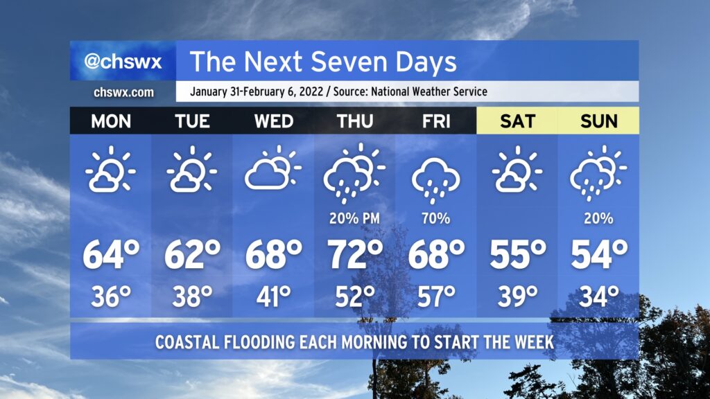
After a couple rather chilly weeks, we’ll give the heavy jackets a bit of a rest as ridging builds in aloft. We start the week with low temperatures in the mid-to-upper 30s and highs in the low-to-mid-60s with plenty of sunshine. Cloud cover ticks up a little bit for Wednesday, but so do temperatures as we get close to 70° in the afternoon. By Thursday, another storm system will be approaching from the west, but we should top out in the low 70s before it starts to get into the area. Right now our best rain chance arrives Friday as the cold front gets through. Saturday will turn much cooler with highs back in the mid-50s. This continues into Sunday, with perhaps a slight rain chance as moisture overruns a wedge of high pressure at the surface.
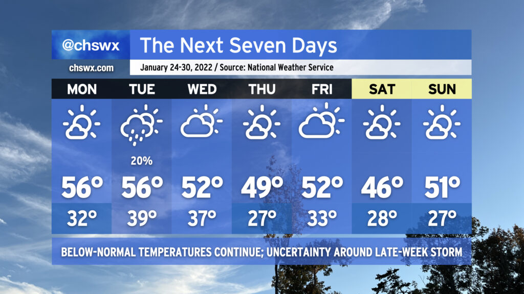
Overall, the forecast is looking a bit quieter (at least right now) as we head into the final full week of January (yes, already). Below-normal temperatures (normal highs for late January are around 60°) will continue as the overall pattern continues to show a ridge in the west and a trough in the east, keeping this side of the country in cooler temperatures and in a more active storm track overall.
Monday looks to be a repeat of today without the 21° start or the falling ice onto the Ravenel Bridge. We’ll start the day again around freezing, but that will be fairly short-lived as temperatures will top out in the mid-50s under mostly sunny skies. Low pressure sliding south of the area could toss some moisture in play on Tuesday with a slight shower chance across the area, but temperatures will remain above freezing. We run a little cooler Wednesday and again on Thursday as a front comes by, with another hard freeze possible overnight Wednesday into Thursday.
By Friday, the forecast becomes a bit more uncertain as we watch for an area of low pressure that looks to develop off the coast of Florida and move northeastward. The global models are pretty far apart on the position of a trough that would push the low further offshore. Right now the ECMWF (Euro) solution favors a dry forecast for us, while the GFS has been slower on the trough and thus keeps the low a little more eastward, spreading some precipitation ashore. We’ll wait to see how things develop, but for now, NWS has kept the area rain-free as we head into Friday and the weekend, which will continue to be significantly cooler than normal. Right now, the forecast shows mornings in the 20s and highs in the mid-40s on Saturday and low 50s on Sunday with generally quiet weather. Stay tuned for changes here, though.
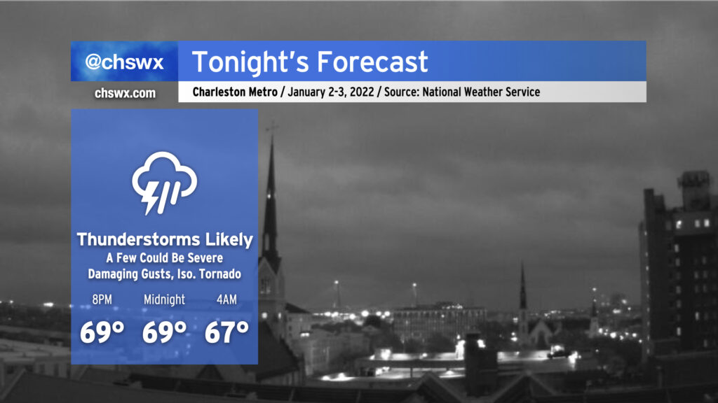
We’ll see some showers and thunderstorms overnight as a cold front approaches the area. No severe weather is expected, but some gusty winds and brief heavy downpours are possible as the line gets through. Rain should clear the area before daybreak.
Once the front is through, temperatures will plummet and clouds will scour out. Expect high temperatures to only top out around the mid-50s with some afternoon sunshine. Then, we’ll have a pretty cold night overnight Monday into Tuesday morning, with lows getting into the upper 20s in the metro area away from the coast. Highs on Tuesday will only top out in the upper 40s despite full sunshine.
After another somewhat hard freeze Wednesday morning, temperatures will begin to moderate some as an upper disturbance approaches from the west and high pressure slips offshore. We might see a few showers Thursday morning as the disturbance swings through, but will close the work week with mostly sunny skies. Showers re-enter the realm of possibilities for the weekend as another front approaches the area. Temperatures will remain generally around if not a click or two below normal.
Tonight’s forecast is rather tricky. We’ve had a good bit of rain across much of the Tri-County today that has helped to knock temperatures back into the 60s in most spots, but it is still conceivable that a few severe thunderstorms may develop overnight.
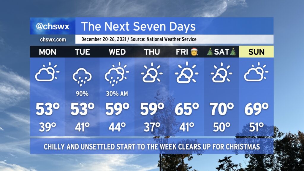
After a cold front came through and chilled us way out today, we will stay in this chilly pattern for a few more days ahead of a late-week warmup as high pressure wedges into the area. Monday looks to remain dry with peeks of sun amongst the clouds; chilly northeasterly winds will keep highs suppressed in the low 50s. Low 50s may be very optimistic for Tuesday’s highs given the potential for strengthening northeasterly winds and expected rainfall around a low pressure system throughout the day helping to reinforce the cool wedge.
Said storm system departs Wednesday, allowing us to dry out and warm up a little bit with highs near 60° in the afternoon. Even fewer clouds look to be an issue for Thursday as temperatures once again approach 60°.
By Friday, we will be heading into a warming trend that’ll put us in the upper 60s to low 70s for Christmas Day with continued sunny skies. Certainly no concerns for sleigh aviation overnight Friday into Christmas morning on Saturday, which is always welcome news.
Aside from the storm system on Tuesday, we’ll need to watch morning high tides this week for the potential for coastal flooding given the recent full moon and strong northeasterly winds. A major coastal flooding event is not expected, but minor salt water flooding could cause a few roads to take on water. We’ll especially need to watch Tuesday in case heavy rain coincides with high tide. Fortunately, as the pressure gradient near the coast relaxes, so will the coastal flooding threat.
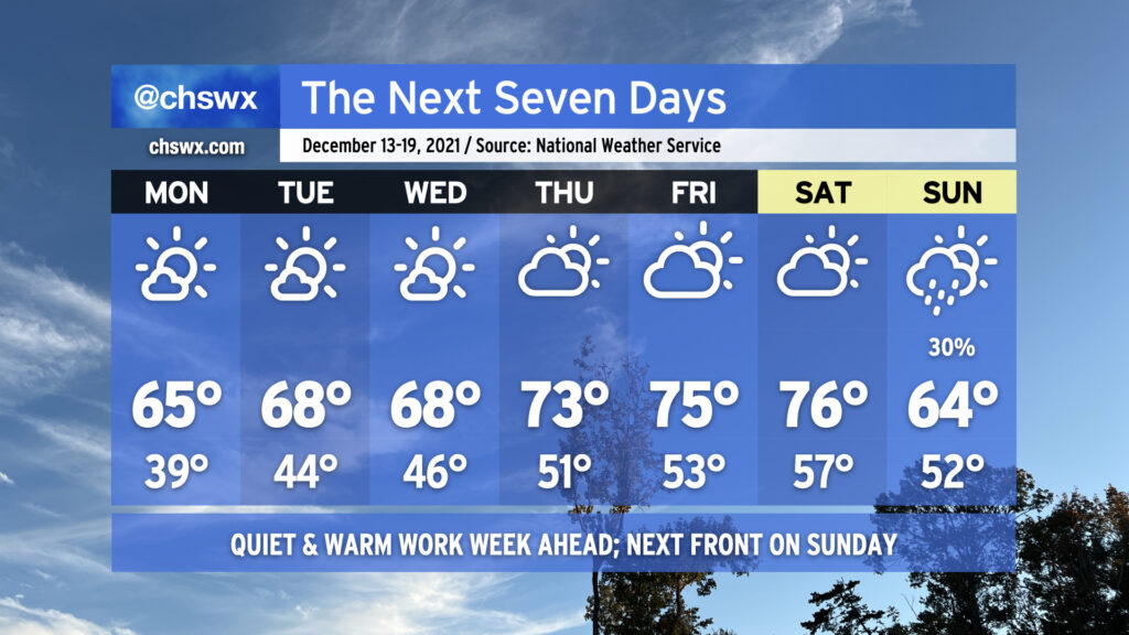
High pressure at the surface and aloft will make for a quiet and increasingly warm work week across the Lowcountry. We’ll start Monday on a chilly note as lows should dip into the 30s across much of the area away from the immediate coast. Highs will top out in the mid-60s under mostly sunny skies. We turn a little warmer on Tuesday and Wednesday, starting out with mid-40s and ending in the upper 60s. As high pressure slips offshore, we’ll start to see even more of a warming trend establish itself to close out the week, with highs in the 70s Thursday through Saturday. Our next front and rain chance looks to arrive Sunday, with showers possible and highs topping out in the mid-60s. Other than that, though, there are no weather worries to speak of other than the potential for drought to continue to expand across parts of the Southeast.
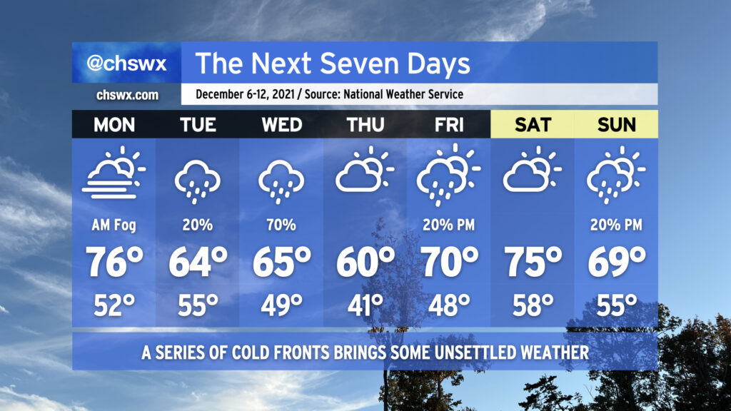
The week ahead features something we haven’t seen in a little while: legitimate rain chances across the metro area, thanks to a couple cold fronts poised to affect the area throughout the week.
Monday begins with another foggy start, with the potential for dense fog certainly in play across much of the area to start the day. Be ready to slow down and use low beams during the morning commute. Temperatures will then rise into the mid-70s despite predominant cloud cover.
Temperatures take a tumble Tuesday as a cold front backdoors into the area, allowing high pressure to wedge down from the north. A few showers can’t be ruled out as southwest winds aloft overrun the wedge, causing lift, clouds, and some precipitation. The better shot of rain is on Wednesday as some upper-level help arrives to improve forcing for ascent and helps to shove another cold front offshore. Thursday looks to be the coolest day of the set as another high pressure wedge looks to take hold, keeping partly to mostly cloudy skies in place with temperatures struggling to reach 60°. We warm back into the 70s on Friday as we head into the weekend with slight shower chances at times.
We’ll also need to continue to monitor morning high tides for the first part of the week for minor tidal flooding thanks to the recent new moon at perigee. Right now, it looks like the 9:21am high tide on Monday could top out between 7.1-7.3′, which would produce some flooding near Gadsden Creek and perhaps even into the City Market. Tuesday and Wednesday mornings could also see minor flooding episodes. Keep an ear out for Coastal Flood Advisories from the National Weather Service.
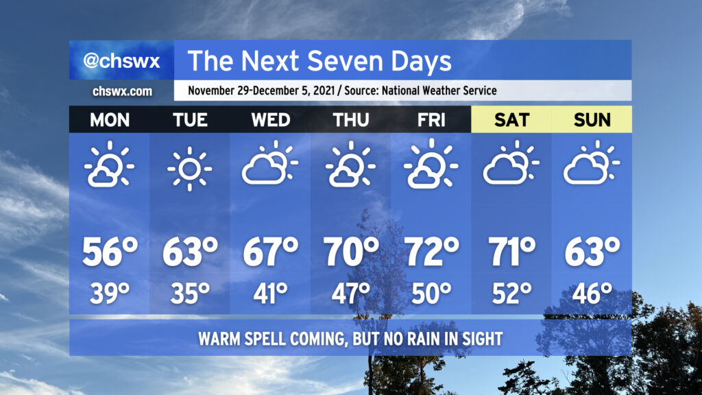
Below-normal temperatures and mostly sunny skies will continue through Tuesday to close out November, meteorological fall, and hurricane season as a weak front gets through overnight to reinforce the cooler airmass in place. Changes are coming, though — as the calendar turns to December and the beginning of meteorological winter, we’re gonna get warmer. The warming trend begins Wednesday, and we’ll look for temperatures in the low 70s for a spell Thursday-Saturday with generally partly cloudy to mostly sunny skies before another front gets through Sunday, sending temperatures a few degrees back below normal.
One thing that’s not forecasted? Rain, at least this week. Persistent dry air continues to keep any sort of rain to a bare minimum across the area with tonight’s frontal passage and will likely at least hamper rainfall development over land with Sunday’s passage, too. Peeking ahead in time, models suggest that the second week of December could see a little bit more in the way of precipitation, but we’ll need to see if that signal holds. For now, though, a good chunk of the Tri-County remains in abnormally dry conditions, with some of the northern fringes creeping into moderate drought. I expect this drought area to expand with Thursday’s Drought Monitor update.
For now, though, we will continue to savor the quiet weather. Have a great week ahead, and Happy Hanukkah to all of you who are celebrating!
Today’s high of 73° could quite possibly be the last 70s we experience for the rest of November as a prolonged spell of below-normal temperatures is in the cards for the upcoming week. We start the abbreviated work week on a somewhat showery note as a cold front approaches the area during the day Monday. Rain chances tend to diminish as the front gets closer to the coast, but a few of you could see a few hundredths of an inch of rain during the day. The front gets through later Monday, and by Monday evening, cold air will rush into the area from the north as high pressure builds in.
We’ll start Tuesday in the mid-30s away from the locally cooler coastline, and could flirt with freezing conditions in some pockets well inland. Factor in the breezy north wind, and it’ll feel closer to the upper 20s in the morning. Highs will struggle to the low 50s in the afternoon with that persistent north wind continuing to make it feel a little cooler.
Calming winds and clear skies will provide excellent conditions for radiational cooling overnight Tuesday into Wednesday, and it appears likely that much of the area away from the coast will see its first freeze of the season with frost developing in other locations. Be ready to cover or bring in sensitive vegetation and make sure your pets have a warm place to be! Highs on Wednesday will run a little warmer than Tuesday, but still don’t look to crack 60°.
After another chilly start on Thanksgiving morning, temperatures will warm nicely into the mid-60s under partly cloudy skies. We could see a few showers on Black Friday as another cold front approaches the area with a reinforcing round of cooler air for the weekend, which looks to remain rain-free as of right now.