Rain-free conditions come to an end Thursday as we should see some scattered showers from time to time courtesy of developing low pressure well offshore. We’ll get off to a much warmer start than the previous couple days, with lows across the metro in the upper 60s to around 70°. Expect a scattering of showers and maybe some rumbles of thunder throughout the day, coming ashore within onshore flow. A few heavy downpours can’t be ruled out. Highs top out in the low 80s.
We’ll get close to coastal flood stage with Thursday afternoon’s high tide, forecast to peak around 12:41 PM, thanks to the increasing northeasterly flow, which tends to pile water up quite efficiently, so we’ll need to keep an eye on that in case some salt water works into the area.
After an incredibly soggy day across the Charleston metro, featuring another round of downtown flooding and rain totals exceeding 4″ in some spots, we get a couple days to dry out to start the work week. We start Monday in the mid-to-upper 60s and top out in the mid-80s as dewpoints fall into the low 60s throughout the day, which will make it an awfully nice day for an emotional support lunch outdoors as we head back to work. We keep the vibe going into Tuesday, with a somewhat cooler start thanks to the lower dewpoints in the area. A few more clouds are expected, but otherwise expect another nice day. Winds go northeasterly on Wednesday and could bring a few showers or storms into the area, but otherwise, much of us should stay rain-free.
Things get weird starting Thursday and heading into the weekend. Models are in good agreement that low pressure will spin up nearby in something resembling more of a nor’easter setup than anything else. However, if it stays over water (which is still plenty warm), there’s a chance it could try to acquire some tropical characteristics. Right now, the forecast is for some periods of rain and some gusty winds particularly near the beaches, and regardless of whether the storm is cold-core, warm-core, or hybrid, the impacts should be relatively straightforward. Obviously, we’ll keep an eye on this, but for now, not seeing anything extraordinary here. Stay tuned to forecast updates in the meantime.
Well, if you’re going to do outside stuff this weekend, Saturday’s probably the day to do it. It’s going to be a gorgeous day — low humidity, plenty of sunshine, and comfortably warm temperatures in the mid-80s after starting out in the upper 50s to low 60s across the metro.
High pressure will slip offshore late Saturday, and dewpoints will climb back into the 70s for Sunday ahead of a cold front. Expect showers and thunderstorms to become somewhat numerous Sunday afternoon into the evening as the front approaches the area. We could see some enhanced rainfall, too, courtesy of a wave of low pressure moving along the front. Temperatures should stay in the low 80s with the expected showers and thunderstorms. Generally, expect .5-1″ of rain across the area, with locally heavier amounts. Severe weather is not expected.
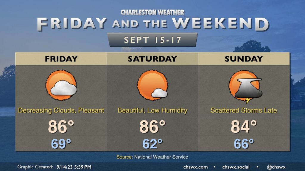
We get a break in the humidity Friday and Saturday as cooler and drier high pressure builds in from the northwest. Temperatures get off to a nice start on Friday, and persistent northeasterly winds will keep highs capped in the mid-80s as cloud cover decreases. Dewpoints, meanwhile, will plummet into the mid-50s, and this will allow relative humidity values to drop below 40%, making for rather comfortable warmth.
Saturday is probably the best day of the set to get outside, as we start the day in the low 60s before heading back to the mid-80s in the afternoon under mostly sunny skies. Dewpoints will again mix out into the mid-50s during the day, and we’ll have another round of sub-40% humidity.
High pressure slips offshore overnight Saturday, and by Sunday dewpoints will be rebounding back into the mid-to-upper 60s. Another front will be approaching the area during the day, and this will be the impetus for showers and thunderstorms as we get later into Sunday and Sunday evening. Highs top out in the mid-80s. Overall, expect temperatures to remain at or a little below normal as we head into next week.
A cold front will slip offshore early Thursday morning, but we won’t quite be feeling it just yet as some showers and thunderstorms will still be possible as moisture lingers across the area during the day Thursday. Highs top out once again in the upper 80s before showers and a few storms fire. Instability isn’t great and severe weather is not expected, though some heavy rain will yet be possible at times. The best chance to see a shower or storm looks to be in the afternoon and early evening hours.
Shower and thunderstorm chances — as well as temperatures — peak on Wednesday ahead of a cold front approaching the area. We’ll start the day in the low 70s with highs heading into the upper 80s in the afternoon before thunderstorms erupt generally along the seabreeze. A few thunderstorms could produce some strong wind gusts, with heavy rain and frequent lightning the more widespread concerns. The front should stall out to our west for the balance of the day before making its move through the area overnight Wednesday.
The airmass change behind the front will be somewhat slow at first. We’ll certainly see slightly lower dewpoints Thursday with air temperatures topping out a few degrees cooler as well, generally in the mid-80s. However, there should be enough low-level moisture to allow for a few popup showers and storms in the afternoon, so be ready for the potential to dodge a storm or two.
The airmass change picks up steam later Thursday into Friday, which looks positively brilliant. Expect lows in the mid-60s Friday to be followed by highs in the low 80s in the afternoon under nearly unfettered sunshine. Dewpoints will fall into the low-to-mid-50s during the day, providing a comfortably warm feel to the air. We’ll keep this going into the weekend, too, with lows bottoming out near 60° on Saturday. (Might even record a few upper 50s in some spots!) Fall is indeed coming, but these transitional seasons can be a little frustrating at times as the weather see-saws back and forth. (Hence “transitional season.”
Tuesday’s forecast will once again feature a seasonably warm and humid airmass that’ll give rise to some showers and thunderstorms in the afternoon, generally along and ahead of the seabreeze. We start the day in the low-to-mid-70s. Some fog may be around as we start the day, so be ready for possible visibility reductions particularly as you get further inland. Highs top out around 90° in the afternoon before a few storms fire, which will cool things off for some of us. A couple strong storms are possible, but don’t expect a widespread severe weather issue.
We will get off to a warm start for the first part of the work week, but a front will bring another taste of fall for the second half into the weekend.
Sunday should have a similar flair to Saturday with scattered storms and sunshine mixing in afterward. Like Saturday, we could see a few storms possible in the morning before gradually pushing inland during the day. And like Saturday, we should also see some decent sunshine kick in as well, with highs approaching 90° in the afternoon. Overall, not expecting a full rainout anywhere, but a few spots could see some heavy downpours with a quick inch of rain or so possible (much like parts of West Ashley and North Charleston saw this morning!)
Showers and thunderstorms will be off and on throughout the weekend, particularly Saturday as a disturbance aloft ripples through the area. Winds turning onshore will bring some more moist air into the area, and we could see showers and thunderstorms begin to affect the area by daybreak. Some spots could see some fairly heavy rain at times, and a strong or severe storm isn’t totally out of the realm of possibility (though is rather unlikely). It won’t rain all day, but be ready to enact indoor plans on Saturday if necessary. Highs top out in the mid-to-upper 80s given the cloud cover and rain expected.
Storms should be a little more sparse coverage-wise throughout the day Sunday, though most of us should see at least some rainfall at some point throughout the day. Much like Saturday, the rain risk looks to start at the coast in the morning hours before shifting inland with the seabreeze in the afternoon. Once again, a storm or two could be strong, and some of the rain could be heavy at times, but widespread severe weather just doesn’t seem to be in the equation. Highs on Sunday run a click warmer, but still generally in the upper 80s.