Jared Smith founded @chswx on Twitter in 2008 as an experiment in disseminating weather data through social media. In the ensuing decade-and-a-half, @chswx has provided live coverage of tropical cyclones, tornadoes, severe weather, and even a couple bouts of winter weather to the good people of Charleston, SC.
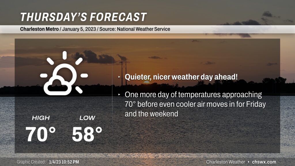
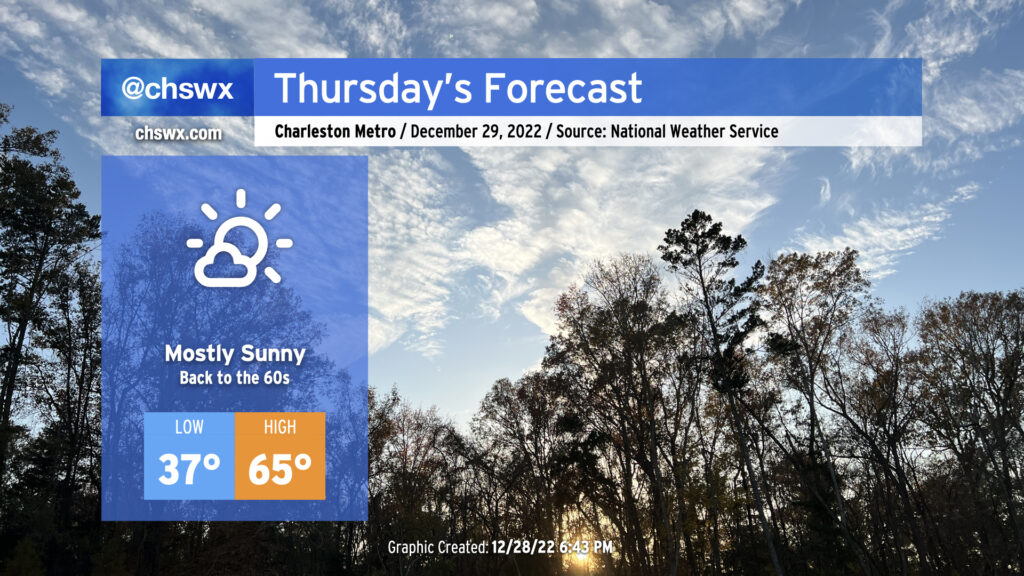
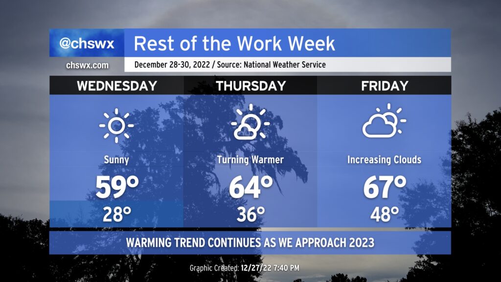
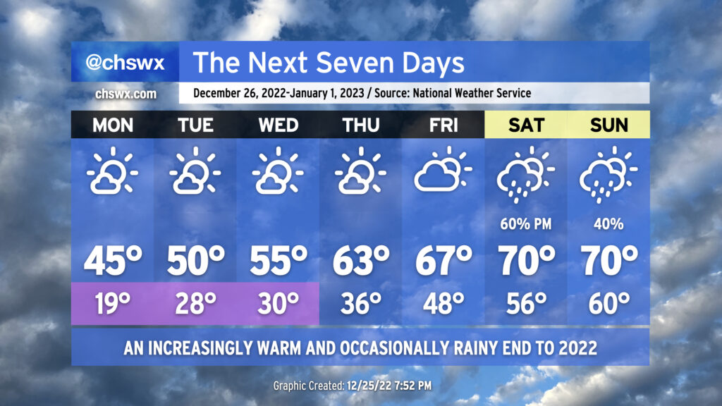
Expect quieter weather for Thursday — and into Friday and the weekend — as a cold front gets through early in the morning. We’ll start the day well above normal with lows bottoming out in the upper 50s. Clouds will scour out post-frontal passage and some cooler air will begin to filter into the area. Temperatures, however, should still be able to reach around 70° in the afternoon for one final time in this warm spell. We’ll turn much cooler as we head into Friday, when highs should only top out in the upper 50s — in other words, Thursday’s lows are Friday’s highs!
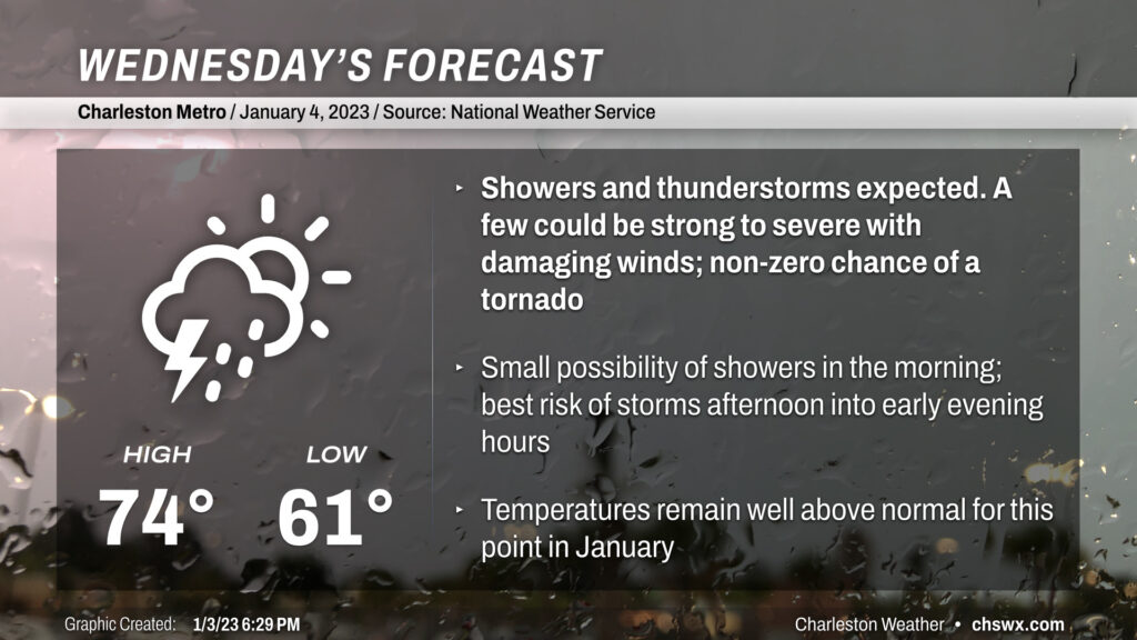
Wednesday will be another mild day, with temperatures running in the mid-70s ahead of a storm system which will turn the afternoon and evening hours unsettled with the risk of a strong storm or two.
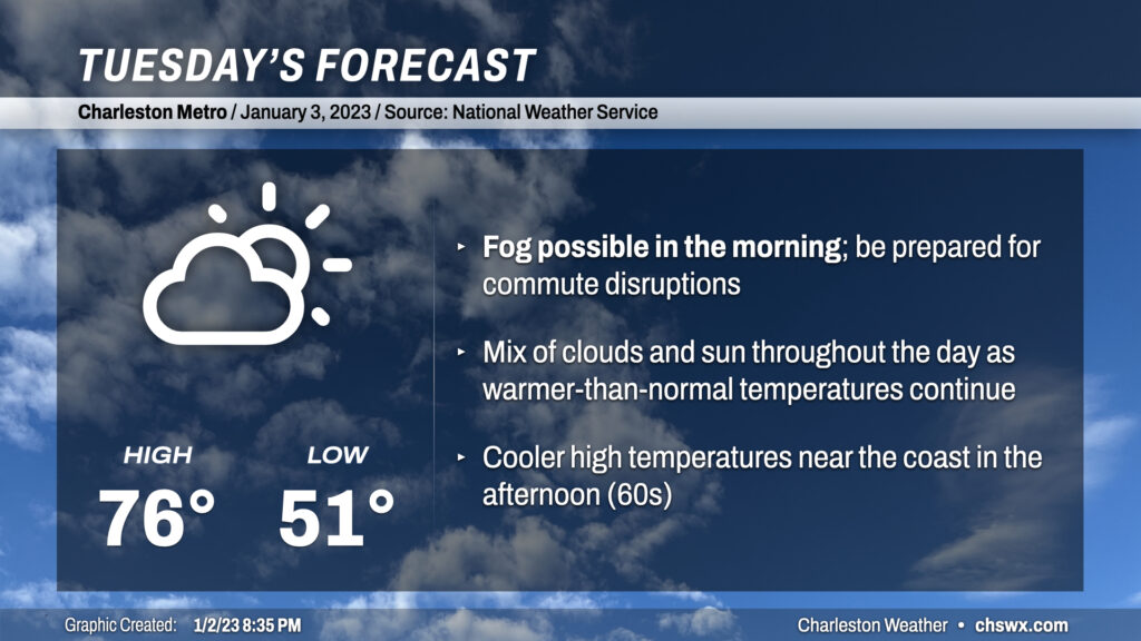
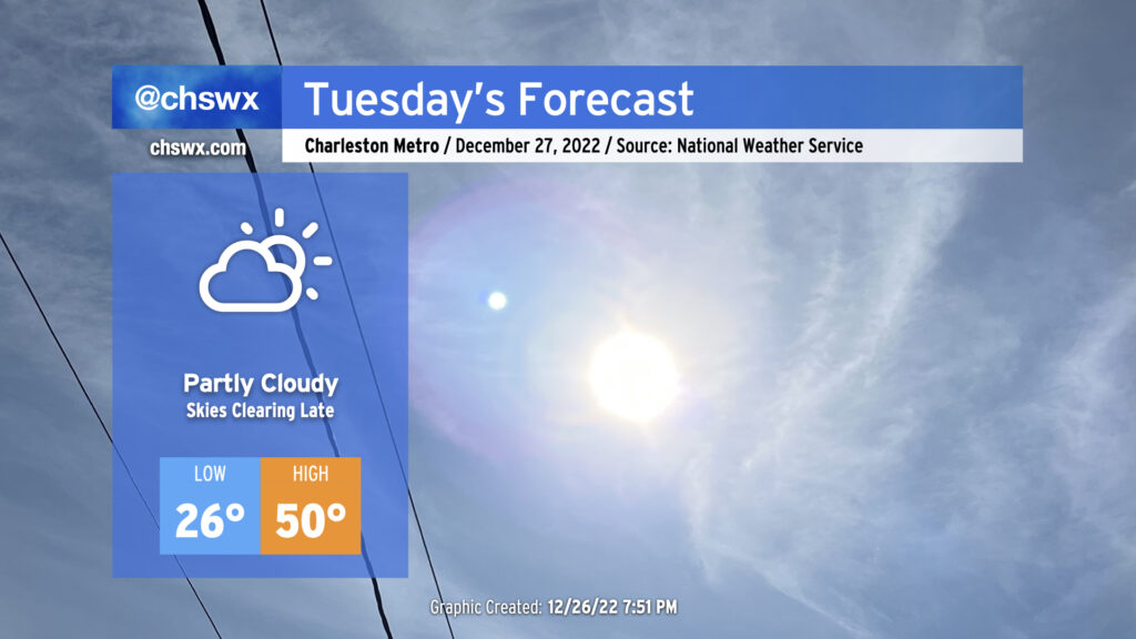
Tuesday looks to start much in the same fashion as the past few days: at a minimum, patches of fog, potentially dense with visibility below ¼ of a mile at times, should develop overnight and should persist into mid-morning. As of this writing, a Dense Fog Advisory is in effect for Charleston County and Berkeley County around Cainhoy and Daniel Island through 10am. If fog does indeed persist and even expand, you’ll want to be sure to allow extra following distance and use low beams so that other drivers can more readily see you.
Once the fog mixes out, partly cloudy to mostly sunny skies will kick back in, and temperatures should respond by heading into the mid-70s by afternoon (sticking closer to the low-to-mid-60s near the coast, though, given much cooler shelf waters). Clouds should be on the increase in the evening as our next storm system approaches from the west.
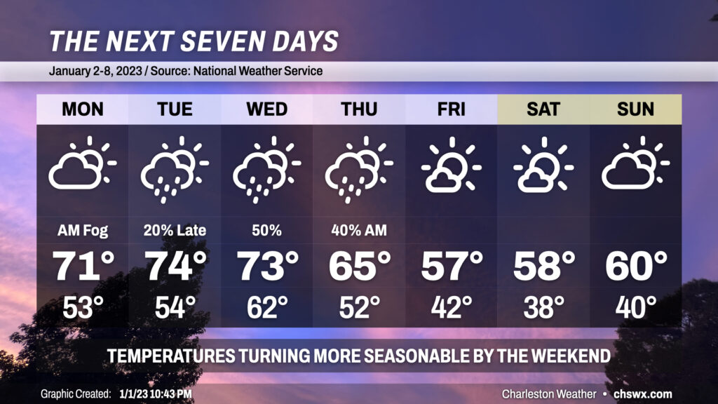
We’ve got a few more warm and muggy days ahead to start 2023 before a front gets through mid-week, bringing temperatures closer to early January normals.
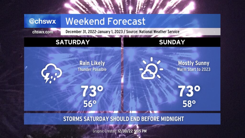
2022 will come to an unsettled end across the Lowcountry as showers and perhaps a few thunderstorms develop and move through ahead of a cold front. A stronger storm or two will be possible near I-95, but otherwise expect generally off and on showers. The best risk for showers will occur in the afternoon through the early evening hours; yes, it is conceivable we may have the precipitation out of here as the clock strikes midnight. It will certainly be mild, with highs in the low 70s. Temperatures will run in the upper 50s as 2023 begins, so it should be fairly comfy with a light jacket.
The atmosphere will be drying out during the day Sunday, with cloud cover decreasing and some drier air moving in. It’ll still be warm, though, thanks to high pressure ridging aloft: once again, expect highs in the low to mid-70s. Overall, not a bad start to 2023!
After a high of 62° today — the first time since December 17 that we’ve crossed the 60° threshold — we will be back into the 60s tomorrow across the metro, with temperatures running a few degrees warmer than they did today. Most notably, those of us east of Highway 17-A will remain above freezing into tomorrow morning for the first time since December 23. Those of you along and inland of 17-A will want to take freezing weather precautions for just one more night as lows dip below 32° for a time, with a few upper 20s possible in more sheltered locations. However, many of us will not need to drip faucets or take other precautions tonight (though bringing your pets in is always a good idea this time of year).
We will continue to trend warmer heading toward New Year’s Weekend. First, though, we’ve got to get through one more night of subfreezing temperatures, and then we get a long break. But once again tonight, though, be sure to have a faucet dripping, pipes insulated, pets indoors, plants covered, and the people in your life accounted for and warm. Temperatures will bottom out in the upper 20s — certainly not as severe of a freeze as we have seen recently — across the metro area. The good news is that we’ll warm nicely with temperatures approaching 60° in the afternoon under brilliantly sunny skies.
We head back well below freezing overnight into Tuesday morning as gradually modifying Arctic air remains in place across the area and mostly clear skies allow for good radiational cooling. This is going to be another night where you’re going to want to have a faucet or two going to prevent burst pipes or other leaks from developing. Make sure pets are inside, sensitive plants are indoors or covered, and your loved ones and neighbors are warm.
Temperatures should be above freezing by 10am on their way to the low 50s in the afternoon. A shortwave trough will be swinging by in the morning through early afternoon, instigating some cloud cover but little else as very dry air remains in place across the area. We should see some clearing begin to take shape before sunset, after which temperatures will once again quickly fall back into the 30s.
We begin the final week of 2022 with Arctic air continuing to make its presence felt across the area. We’ll start Monday in the upper teens to low 20s, with freezing temperatures all the way to the coast once again. It’ll be another night to make sure that pets, plants, and people are well accounted for, and that pipes are protected with extra insulation and a dripping faucet. Highs will top out again in the low-to-mid-40s under predominantly sunny skies.
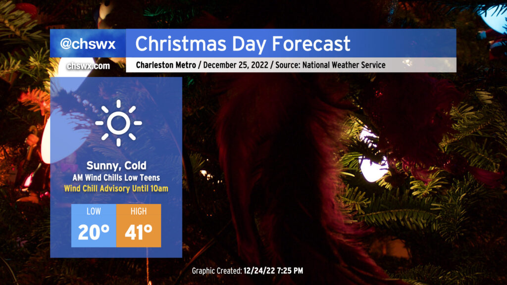
After record-breaking cold on Christmas Eve, we have another round of cold — but perhaps not quite as cold — weather for Christmas Day.
We begin the day with another Wind Chill Advisory as another round of low teens wind chills is forecast across the area. Air temperatures will drop to around 20°, with another dip into the teens possible further inland as well as in more rural areas. The good news is that after what should amount to about 40 consecutive hours below freezing, we will finally exceed the melting point by early afternoon, which will give us some much-needed thaw time. Skies will be mostly clear throughout the day, and at least some unfiltered sunshine will help it feel not as bitterly cold as it was on Saturday, though wind chills will still, at best, run in the low 30s.