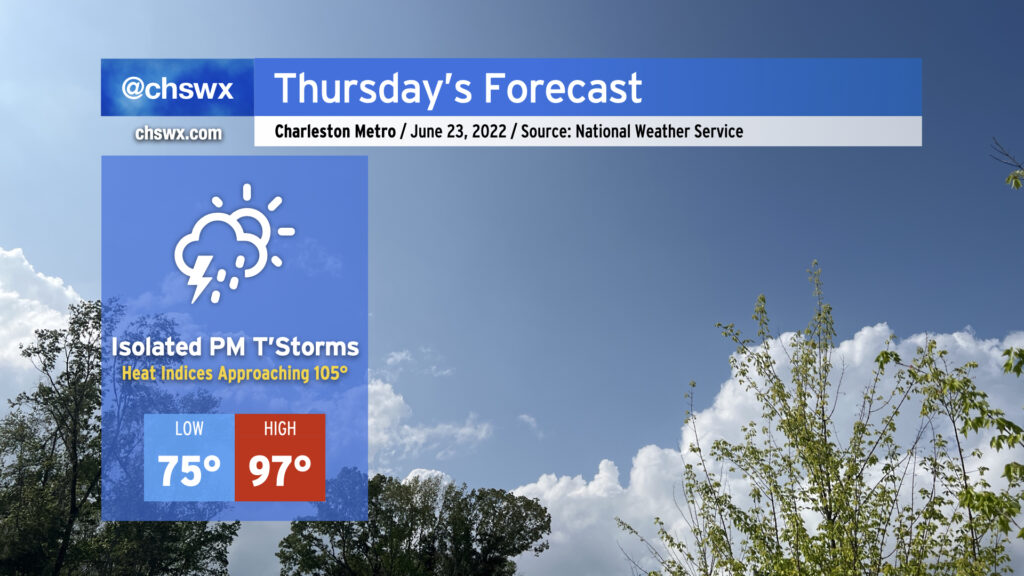
Thursday will be the hottest day this week as air temperatures return to the mid-to-upper 90s across the Lowcountry in the afternoon. Unfortunately, dewpoints will also have recovered back into the 70s, and that could put us close to heat advisory territory for Thursday afternoon as heat indices could approach 105°. There will, however, be a shot at some isolated thunderstorms later in the afternoon into the evening hours as the seabreeze makes its move inland. Lightning and gusty winds will be the primary concern from any thunderstorm that forms, but so far widespread severe weather doesn’t look likely.
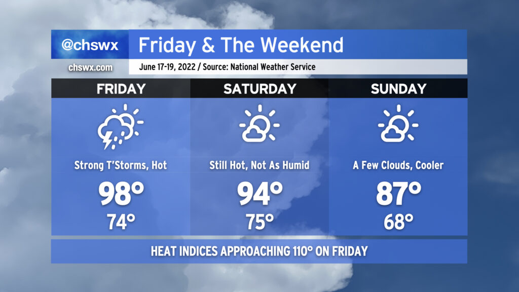
We have another potentially boy-band-hot (98°) day on tap for Friday as temperatures soar ahead of a cold front. Expect heat indices to once again approach 110°, with a heat advisory a near-certainty as a result. Said heat and humidity will translate to plenty of thunderstorm fuel for potential strong to severe thunderstorms in the evening hours ahead of the front. There’s still model disagreement about exactly when and where thunderstorms will fire, but if and when they do, a few will be capable of damaging wind gusts. You’ll want the weather radio nearby tomorrow evening, especially if you are out and about.
The front gets through late Friday into early Saturday, shutting off rain chances and even helping to dehumidify us a touch. Saturday will still be hot, with air temperatures reaching the mid-90s, but dewpoints in the upper 60s as opposed to the mid-70s will keep heat indices generally below 100°. Sunday looks even better — honestly a pretty fantastic day to get outdoors, particularly in mid-June — with a punch of cooler and drier air keeping air temperatures to the mid-80s for much of the area. The respite will be short-lived, though, as temperatures soar once again by the middle of next week, possibly flirting with 100° on Wednesday.
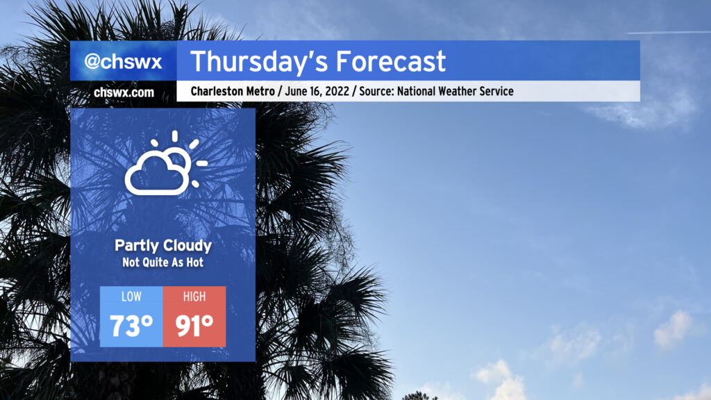
Thursday will run a little cooler — 91° with a heat index of 94° certainly qualifies — as onshore flow behind a backdoor cold front gives us a little break before the heat picks back up on Friday. With the slightly cooler weather comes a somewhat more stable atmosphere, which will keep the risk for afternoon showers and thunderstorms to a bare minimum. All in all, should be a fairly decent day for an outdoor dinner. (Might still be a bit much for eating lunch outside, though.)
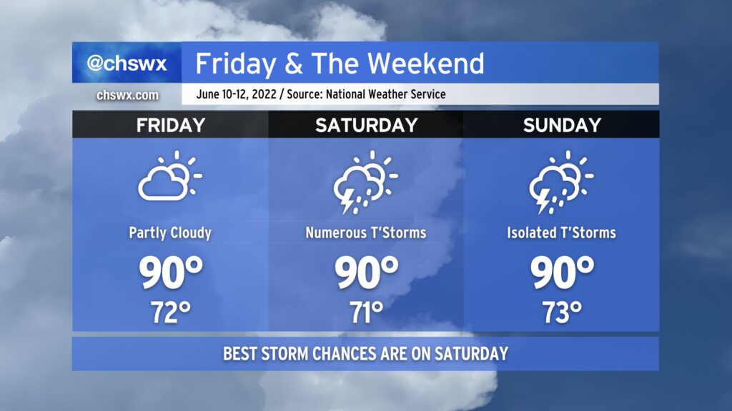
Friday and the weekend will remain on the warm side, with the best chance at showers and thunderstorms coming on Saturday before tapering off on Sunday.
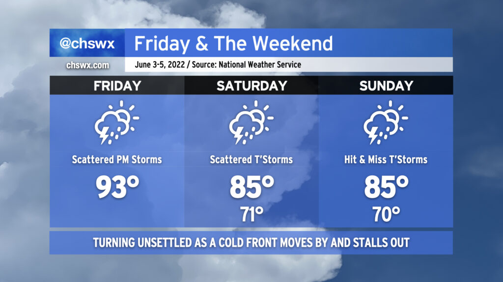
We’ll be the beneficiary of some drier air on Friday, which should help keep thunderstorms to a minimum and put a little governor on the humidity. This will be short-lived, though, as the front that helps to usher in this drier air lifts back north of the area, putting us back in the soup on Saturday. It looks like showers and thunderstorms will begin to break out by mid-morning and continue well into the evening hours. Exact placement of storms will be driven by where storms initially fire and the subsequent propagation of outflow boundaries and the seabreeze. The trough driving some of this unsettled weather begins to lift north on Sunday, leaving us with generally standard chances of thunderstorms on the seabreeze in the afternoon.
Overall, expect highs around 90° each day ahead of thunderstorms, with heat indices generally in the mid-90s. This’ll feel cool compared to what’s coming down the pike for next week — it looks like we might have a few days of near-heat advisory conditions (heat indices 105°+) with little in the way of storms to help cool things off at least temporarily. We’ll want to watch trends closely for this potentially sweltering heat!
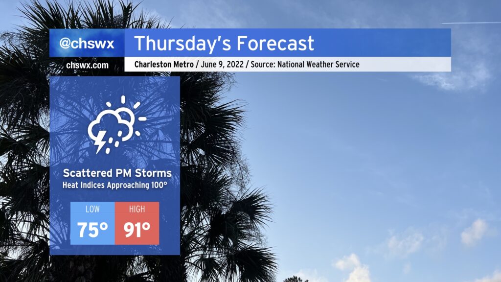
Despite the air temperature topping out around 91°, Thursday’s going to be the hottest day of the week because of quite a bit of humidity. Heat indices could approach 100° in the afternoon before scattered thunderstorms develop along the inland-moving seabreeze. A storm or two could be on the strong side where outflow boundaries intersect, but as is typical in the summertime, any severe weather will be quite localized. Heat will certainly affect everyone, though, so be sure that you’re getting plenty of water and shade if you’re outdoors in the height of the afternoon.
We have one more fairly hot day in store before a cold front moves into the area later tonight, bringing with it some unsettled weather — perhaps a strong thunderstorm or two — before moving through and stalling out to our southeast, keeping rain chances in play for the weekend (though turning a little better by Sunday).
Today will start as the past few days have, with temperatures heading into the 90s by early afternoon. Around 2-3 PM, we should start to see showers and thunderstorms fire on the seabreeze — perhaps as close to the coast as the US-17 corridor — before gradually moving inland with time. At the same time, we’ll be watching the cold front to our north and west continue to press into the Carolinas. With the seabreeze, other colliding outflow boundaries, and the approaching front, a couple storms could turn strong to severe, particularly inland. Damaging wind gusts are the primary concern.
The convection-allowing models hint at a lull in the activity this evening before the front gets through the area, perhaps spreading some showers and a few thunderstorms into the area after midnight. Once the front gets through, we will feel somewhat cooler temperatures for the weekend courtesy of winds turning east and northeast as high pressure wedges in from the north. Winds could be a little breezy thanks to a pressure gradient between the aforementioned high pressure and what is expected to be Tropical Storm Alex as it passes well to our south. Alex could also help bring some additional moisture into the area particularly on Saturday, which will keep shower and thunderstorm chances elevated throughout the day (though the highest in the afternoon with daytime heating). By Sunday, the atmosphere dries out a little, but a few hit or miss showers and thunderstorms remain possible into the early evening.
Bottom line for your weekend: It won’t rain all day at any one particular location, but have that rain plan ready to go for any outdoor activities, particularly on Saturday when the probability of precipitation is higher. (And enjoy the cooler temperatures!)
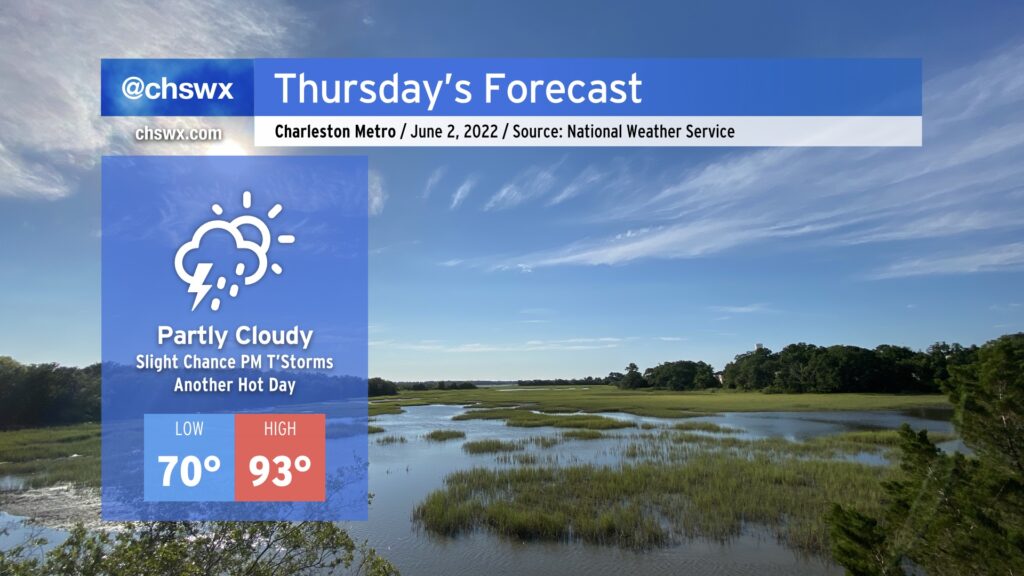
Another hot day is in store for Thursday as highs once again soar into the 90s under partly cloudy skies. Add humidity in, and heat indices could reach 96-97°. There’s a slight chance of a popup thunderstorm or two tomorrow, but the vast majority of us once again look to remain rain-free. If storms do fire, they could produce some gusty winds, heavy rain, and cloud-to-ground lightning, so be ready to move indoors if you’ve got outdoor plans tomorrow afternoon.
Thursday looks to be another warm and somewhat muggy day as onshore flow keeps humidity up a notch or two. Temperatures will top out a little warmer than they did today, ending up around on the higher end of the mid-80s away from the coastline; factor in the humidity and we’ll see heat indices running in the low 90s. We look to stay rain-free, though, as drier air aloft stays in place for one more day.
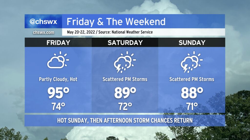
We hit 95° at the airport today, making it the warmest day of the year thus far in the Charleston metro area. As of this writing, the cap has held, too, and there are no thunderstorms to speak of. We should repeat this performance tomorrow under partly cloudy skies, with temperatures starting in the mid-70s in the morning to the low-to-mid-90s in the afternoon. Once again, a dearth of energy and a strong cap will keep thunderstorms at bay for Friday, so don’t count on any heat relief in that regard.
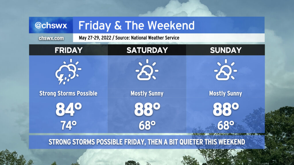
We start to see the high pressure ridge begin to shift away a little on Saturday, though, opening the door for afternoon showers and thunderstorms. They’ll be scattered about, so not everyone will see measurable rain. Where it does rain, though, it could be heavy. Highs top out in the upper 80s to around 90°, tempered by afternoon thunderstorms.
We should see similar weather on Sunday, with even more numerous showers and thunderstorms expected that afternoon. Again, though, some spots may see a downpour while others get little to no measurable precipitation. There also appears to be a risk for a few storms to be on the strong side with strong downburst winds and perhaps hail. Widespread severe weather, at this point, doesn’t appear likely, though.
Scattered showers and thunderstorms remain in the forecast each afternoon thus far next week, so if you miss out on the rain this weekend, there’s still plenty of chances to come.