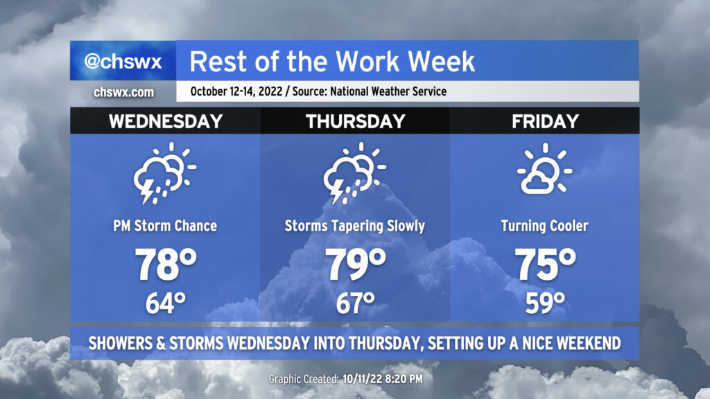
The weather will take a turn more toward unsettled starting Wednesday afternoon as some upper-level energy well out ahead of a cold front helps to induce some showers and thunderstorms across the area.
Wednesday will start fairly mild with lows in the mid-60s thanks to persistent cloud cover. Winds will stay onshore, but despite this, we should still top out solidly in the upper 70s in the afternoon ahead of thunderstorms. It certainly seems that we may get a majority of the day in rain-free, with rain chances starting to head up around commute time.
The greatest risk for showers and thunderstorms looks to be after sunset through early Thursday morning. It’s likely we’ll get a good bit of Thursday morning in rain-free, allowing highs to top out near 80° in the early afternoon. Then, it’s possible that some showers may redevelop ahead of the cold front itself as its timing should coincide with peak heating. The front gets through Thursday evening, and by Friday, we’re starting out quite a bit cooler — upper 50s as opposed to mid-to-upper-60s — with highs topping out in the mid-70s under quite a bit of sunshine. This will set up a beautiful weekend of weather with plenty of sunshine and comfortable temperatures, though perhaps not quite as cool as mentioned yesterday. Still, though, mid-to-upper 70s remain below normal for highs for this point in October.
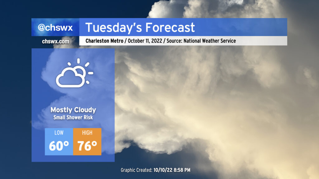
Not much weather to write home about for Tuesday as we get one more mostly dry day in ahead of a cold front which should bring the most substantial rain since Ian to the area for later Wednesday into Thursday. Cloud cover blanketing the area will help keep lows elevated to around 60° to start the day. Breezy onshore winds and continued cloud cover will keep high temperatures capped in the mid-70s. Much as we saw today, there is a small chance of a shower or two in the afternoon, but these won’t be horribly disruptive and should be short-lived if they do end up firing.
Another round of minor to moderate coastal flooding will be possible a couple hours around the predicted 9:40am high tide. Be ready to use alternate routes in case of flooded or closed roads in downtown Charleston.
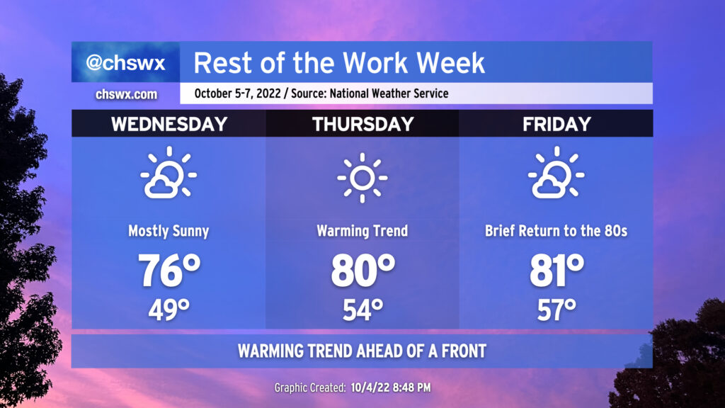
We’ve got another chilly start coming up on Wednesday morning as clear skies and light winds allow for good radiational cooling conditions. We should see temperatures take a dip back into the upper 40s by daybreak (away from the barrier islands and downtown, anyway). From there, a warming trend will commence as a pesky trough associated with the remnants of Ian (yes, really) finally begins to lift away from the area. High pressure will continue to build in from the west, and the resulting downslope flow will begin to help warm temperatures in earnest. Wednesday’s high will top out in the mid-70s under mostly sunny skies. The warming trend continues into Thursday and Friday, with lows bottoming out in the mid-50s and highs reaching around 80-81° each afternoon ahead of a cold front which will swing through Saturday, sending temperatures well back below normal for this point in October by Sunday and the following week. No rainfall is expected; indeed, quite the contrary as mostly sunny skies will continue to dominate.
The only weather hazard of note will be the potential for coastal flooding with the afternoon high tides particularly Thursday and again on Friday (and likely through the weekend) as the moon turns full. Southwesterly winds will keep any coastal flooding to a dull roar Wednesday and Thursday, but we may see water levels creep well into minor flood stage, perhaps approaching moderate flood Friday evening. As the front gets through on Saturday, winds turn northeasterly, which is a very favorable wind direction for coastal flooding, so we’ll need to continue to monitor evening high tides through the weekend for additional rounds of coastal flooding.
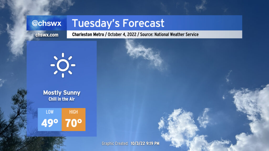
If you liked Monday’s temperatures but would prefer more sun, Tuesday will have you covered. Skies are clearing as I write this post, and we will have a much brighter day ahead. More clear skies will allow temperatures to fall into the upper 40s across much of the metro area away from the immediate coast. The NWS forecast will be around 49°; if that verifies, that would be the first sub-50° low since it was 46° on May 10. Temperatures will rebound only to about 70° despite nearly full sunshine as we sit on the southern periphery of a deep trough of low pressure aloft and a northerly breeze keeps cool air filtering in.
The only potential snag in tomorrow’s weather will be the potential for a little coastal flooding with the mid-afternoon high tide. We might see some salt water coming out of drains around Lockwood Dr. as well as on Hagood and Fishburne near the Joe and Johnson Hagood Stadium. However, a widespread tidal flooding event is not expected.
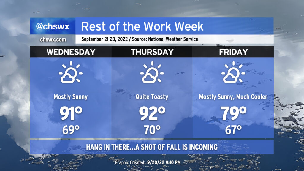
Quiet weather continues for the next several days as high pressure and drier air aloft keep any risk for precipitation very, very low. We’re also staying hot: we reached 91° today and look to do similar numbers for Wednesday under mostly sunny skies. Thursday will be even warmer, with highs reaching the low-to-mid-90s and humidity pushing the heat indices a few degrees warmer.
The heat will break, though, as a cold front swings through late Thursday/early Friday morning. This cold front is legit (and has a great sense of timing, with the autumnal equinox occurring at 9:03 PM Thursday), with a cooler and drier airmass working into the area that’ll knock high temperatures down 10-15° over the previous day. The current NWS forecast doesn’t even crack 80° on Friday! Feels like forever since we’ve had a high that low without any rain, and it will feel quite nice leading into what’ll be an exceptional weekend of weather with mostly sunny skies and seasonable, below-normal temperatures. Hang in there…relief from the heat is coming!
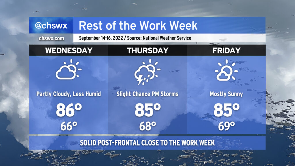
A cold front is working its way through the area this evening which will usher in some positive changes for our weather as we close out the work week.
First thing you’ll notice on Wednesday morning is that it’ll almost feel a little more like fall (away from the coast, anyway — the warm water temperatures will blunt the cooldown some there). Expect lows in the mid-60s to start the day; dewpoints in the low 60s will feel fairly amazing coupled with those temperatures. Highs head to the mid-80s in the afternoon under partly cloudy skies with a northeasterly breeze. Rain chances are very minimal, though the happy hour NAM was a bit intrigued with the idea of a few seabreeze popup showers in the afternoon. This seems to be an outlier solution, though.
Winds turn a touch more easterly on Thursday, which could expose the coastal areas a bit more to the potential for a few showers and storms to drift ashore. This’ll depend on where the front ultimately stalls out, and the probabilities for precipitation remain rather low in general. Otherwise, skies will once again be partly cloudy; lows will run in the upper 60s and highs in the mid-80s with continued comfortable dewpoints.
Friday looks to feature a little bit more in the way of sunshine, though northeasterly winds will keep warmth from running wild as we top out once again in the mid-80s after a nice start to the day with lows just below 70°. Rain chances are once again so low as to be unmentionable, though we’ll want to continue to monitor trends with the front and any waves that might try to form along it.
Overall, though, a solid close to the work week as we emerge from a drencher of a few weeks. Good-looking weather continues into the weekend, too as high pressure continues in place over the area. The only potential fly in the ointment could be a coastal trough that looks to take shape, which may provide a focal point for a few isolated showers in the afternoons, mainly near the coast. We’ll watch trends, but in the meantime, enjoy the tiny sniff of fall — it’s better than what we’ve had, that’s for sure…
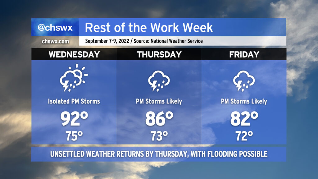
We will get one more day of relatively sparse thunderstorm coverage on Wednesday before the pattern becomes more active again starting Thursday. Highs will once again head into the low 90s across much of the area, and a few mid-90s readings can’t be ruled out either. 90s should reach all the way into downtown once again, too, as westerly winds pin the seabreeze to the immediate coast. As mentioned, a shower or storm can’t be ruled out in the afternoon and evening hours, with the best rain chances inland near an advancing cold front.
On Thursday, a strong influx of Gulf moisture opens up across the area. This, combined with the aforementioned front coming through and subsequently stalling out, will keep us quite unsettled as we head into the weekend. Temperatures will be modulated back to the mid-80s as numerous showers and thunderstorms should develop by afternoon. Friday remains unsettled as well, and some guidance suggests that could be a particularly rainy day, perhaps suppressing highs to the low 80s at best.
We will need to keep an eye on Thursday and Friday evening’s high tides for the potential for salt water flooding, too. Onshore flow combined with the upcoming full moon should drive water levels over 7′ each evening. These tides combined with the potential for heavy rain could spell another round or two of trouble for downtown Charleston — certainly something that will be watched quite carefully over the next few days. Stay tuned for forecast updates as rain timings and amounts become a little clearer as we get those soggier days into range of the higher-resolution model suite.
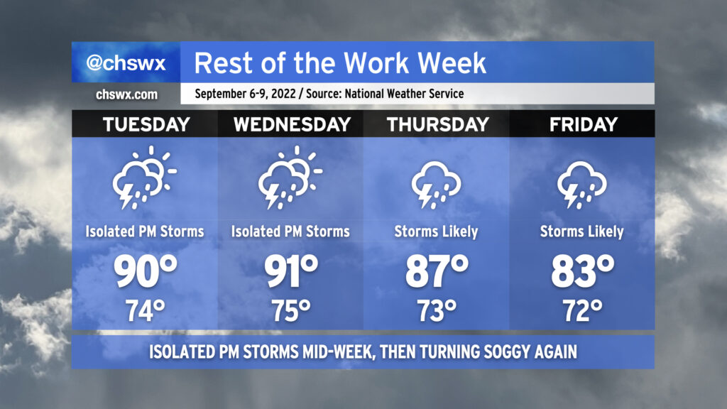
We’ll get a break in the more widespread rain as we head back to work and school on Tuesday as the surface configuration briefly turns a little more summer-like. We won’t stay completely rain-free — isolated to widely scattered showers and thunderstorms will be possible in the afternoon — but it certainly will be a bit of a shift from where we’ve been. The lower shower and storm coverage means temperatures will head to the low 90s in the afternoon; mix in the humidity and it’ll feel closer to 101-102°. We’ll repeat this on Wednesday before another front moves into the area by Thursday. Said front will once again stall out nearby — just not enough oomph yet to get these through at this point in the season — and keep us very unsettled from Thursday through Friday and into the weekend. This will send temperatures down to the upper 80s on Thursday to the low 80s on Friday with numerous showers and thunderstorms expected each afternoon. Heavy rain will be possible, and we may not get out of this week without another bout with flooding somewhere in the metro. Stay tuned to forecast updates.
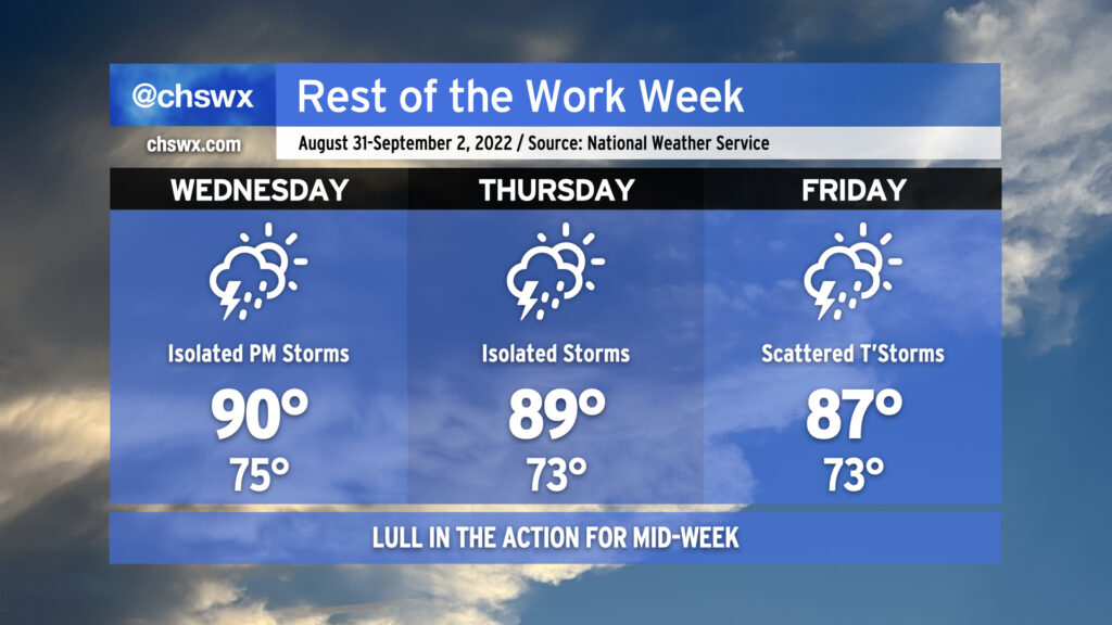
As we head into mid-week and look to round the corner toward Labor Day weekend, we’re going to see a reduction in shower and thunderstorm coverage for a few days as some drier air aloft works in from the north and west. We’ll keep isolated to scattered shower and thunderstorm chances in the forecast as those probabilities won’t be totally eliminated, particularly near the coast, but we shouldn’t see the sustained flooding rains that have been a concern the past couple days. Areas further inland could even see a rain-free couple days, especially on Thursday as a front clears the area and stalls to our south.
As rain chances diminish, temperatures turn back up to a little above normal as we close out August and enter September. Expect highs around 90° for Wednesday; mix in the plentiful humidity and it’ll feel closer to 100-102°. Thursday will run pretty warm, too, with highs around 90° and heat indices in the upper 90s once again expected. Rain chances begin to tick back up on Friday, and that’ll lead to high temperatures topping out a little lower than the previous couple days, generally in the mid-to-upper 80s.
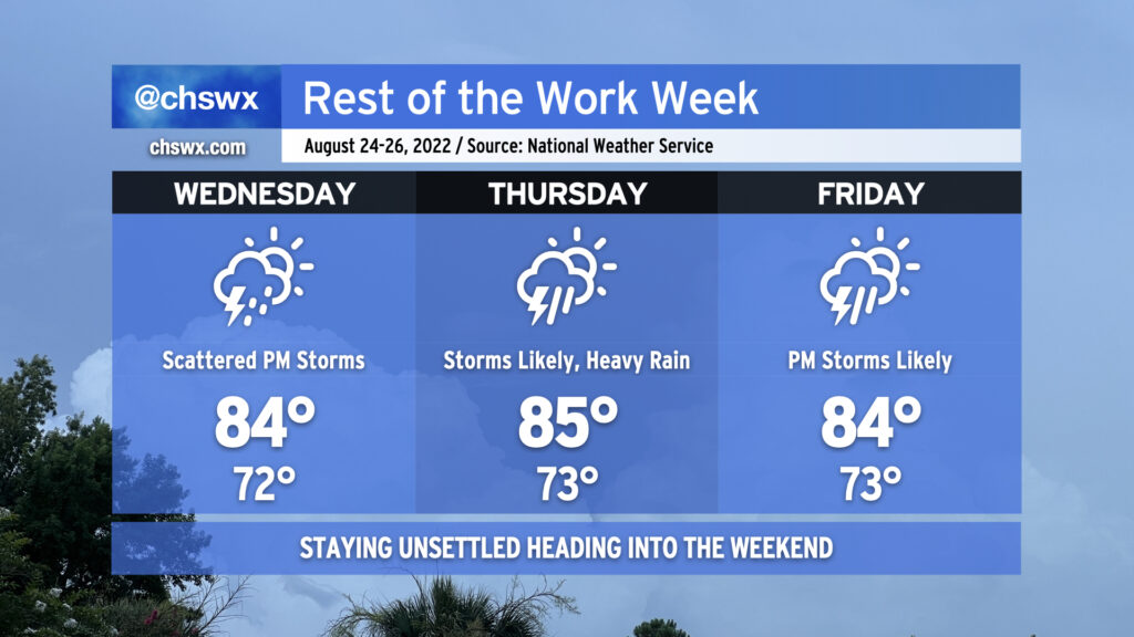
Unsettled weather looks to continue as we close out the work week. Wednesday will represent a little break from more of the widespread rain that we’ve seen of late. However, the atmosphere is still plenty juiced, and daytime heating will help fire off scattered showers and thunderstorms as a result. Bouts of heavy rain are expected, and more flood advisories are possible.
Rain chances head back into the likely category Thursday and Friday as another front moves into the area along with some energy rippling in aloft. Numerous to widespread showers and thunderstorms should redevelop each afternoon, with the threat of heavy rain and maybe some flooding continuing to loom. Exact timing on where and how much it will rain is impossible to know this far out — just know that some of you could see some very heavy rain, while others may see lighter amounts overall.
Temperatures will remain suppressed to the mid-80s each afternoon thanks to cloud cover and nearby showers and storms. Mix in humidity, though, and it’ll feel like the low to mid-90s especially if and when the sun peeks out from time to time.
Looking for rain relief this weekend? I wouldn’t bet on it; we’ll still see decent coverage of showers and thunderstorms especially each afternoon heading into next week. At least temperatures will remain capped in the mid-80s, which doesn’t feel so bad at this point in the year.