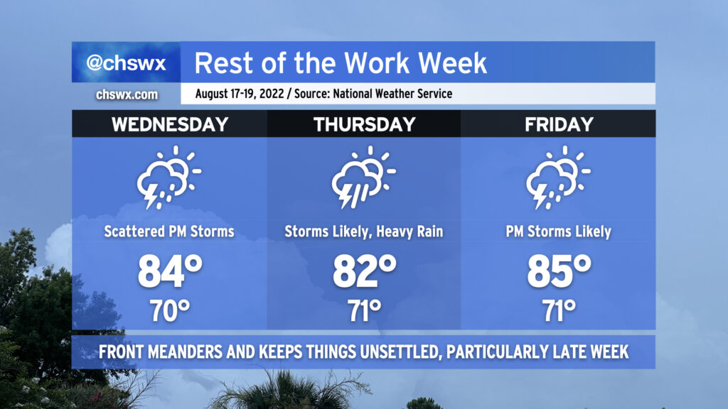
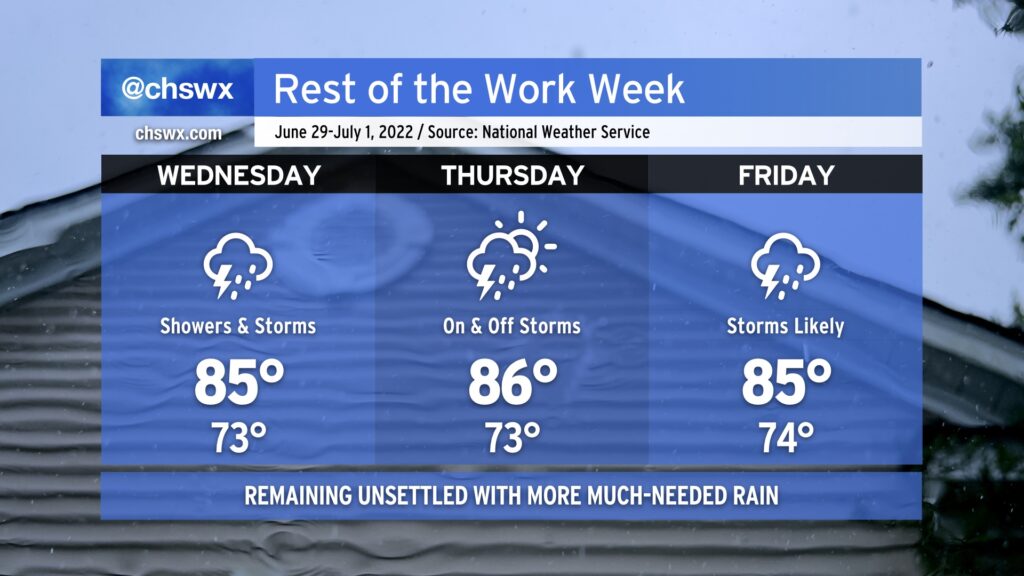
Unsettled — but somewhat cooler — weather continues this week, particularly Thursday into Friday as areas of low pressure along a lingering front as well as impulses around a persistent upper trough help enhance rain chances across the area.
Wednesday will be the driest of the set. As of this writing, the front is driving southward into Georgia, and should stay to our south for much of the day, keeping us in cooler and slightly drier air. While this won’t totally suppress the risk for afternoon showers and thunderstorms, it certainly will keep coverage generally isolated to scattered at best for the first day of school in Charleston County. Highs will top out in the mid-80s, which should make for a reasonably nice day all things considered (though dewpoints around 70° will still feel muggy).
Rain chances begin to ramp up late Wednesday night into Thursday as surface low pressure moves along the front, drawing the boundary a little more north. At the same time, the trough aloft pivots enough to put us in the right entrance region of a jet streak, helping to enhance lift. This combination will make for an unsettled Thursday, with scattered to numerous thunderstorms expected across the area. Heavy rain will be a concern, and we’ll need to keep a close watch for isolated flooding potential. The widespread rain and onshore flow just behind the stalled front should keep Thursday’s high temperatures suppressed to the low 80s.
Friday will run a touch warmer (mid-80s) with a little less coverage of storms to start the day, but showers and thunderstorms become likely in the afternoon after mixing some daytime heating in along with the specter of additional disturbances rounding the base of the upper trough and the persistent stalled front. Heavy rain will once again be a concern with the strongest storms.
This unsettled pattern looks to persist into the weekend as the front continues to meander and weaken, while temperatures turn warmer, closer to mid-August norms.
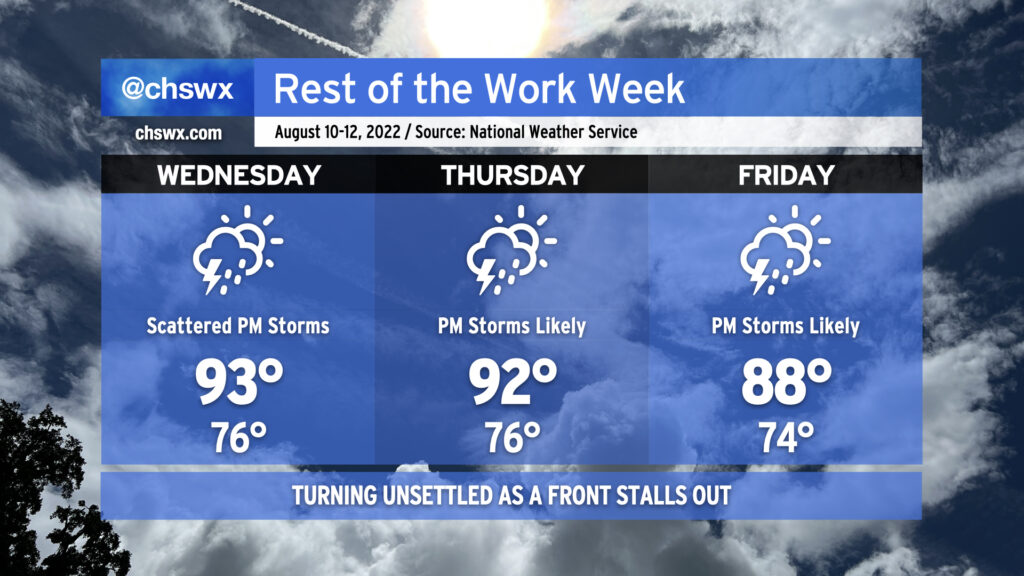
After a relatively quiet Tuesday, we’ll start to see rain chances trend back up starting Wednesday as a trough develops aloft and a cold front presses southward, which will eventually stall out somewhere in the area over the weekend. We still stay quite warm Wednesday into Thursday as highs top out in the low 90s and heat indices top out in the low 100s. Isolated to scattered showers and storms should develop along the seabreeze in the early afternoon and move inland as the day progresses. Same deal for Thursday, though we could see some additional coverage sprout up as the trough digs in a bit more down the East Coast and the front starts to drive southward a little more. By Friday, the front will be getting closer, and this will instigate greater shower and storm coverage as a result. Temperatures will also run a little cooler — by cooler, I mean upper 80s instead of low 90s — thanks to the more widespread cloud cover and rain coverage.
Heading into the weekend, we look to stay unsettled for at least part of Saturday, but drier air will be punching into the area. We should see a taste of mid-60s dewpoints starting Saturday afternoon, leading into what should be a rather gorgeous (by mid-August standards) Sunday. Fingers crossed these trends in the models continue — typically, it is still tough to get fronts this far south at this point in August, but then again, July’s deluge courtesy of southward-pushing fronts showed us that this hasn’t been a very typical summer. Stay tuned.
We’ll be closing out the last work week of July with a good bit of heat as high pressure dominates the weather pattern. Air temperatures will run into the mid-90s each afternoon, while humidity on top will make it feel well into the mid-100s. While heat indices will not reach the post-July 1 heat advisory criteria of 110°, it’ll still be enough to elevate the risk of heat-related illness. Make sure you’re getting plenty of fluids and taking plenty of shady breaks during the heat of the afternoon if you must be outdoors. Low temperatures will run quite warm as well, only bottoming out in the upper 70s away from the coast. Downtown and coastal communities may not see lows dip below 80° for several days. This lack of any real cooling off can add to cumulative heat stress over time.
The aforementioned high pressure will keep afternoon showers and thunderstorms to a minimum, with only isolated coverage expected along and ahead of the seabreeze on Wednesday and Thursday, with unmentionably low rain chances on Friday. It’s hard to stay totally rain-free this time of year, but don’t expect much out of storms over the next few days.
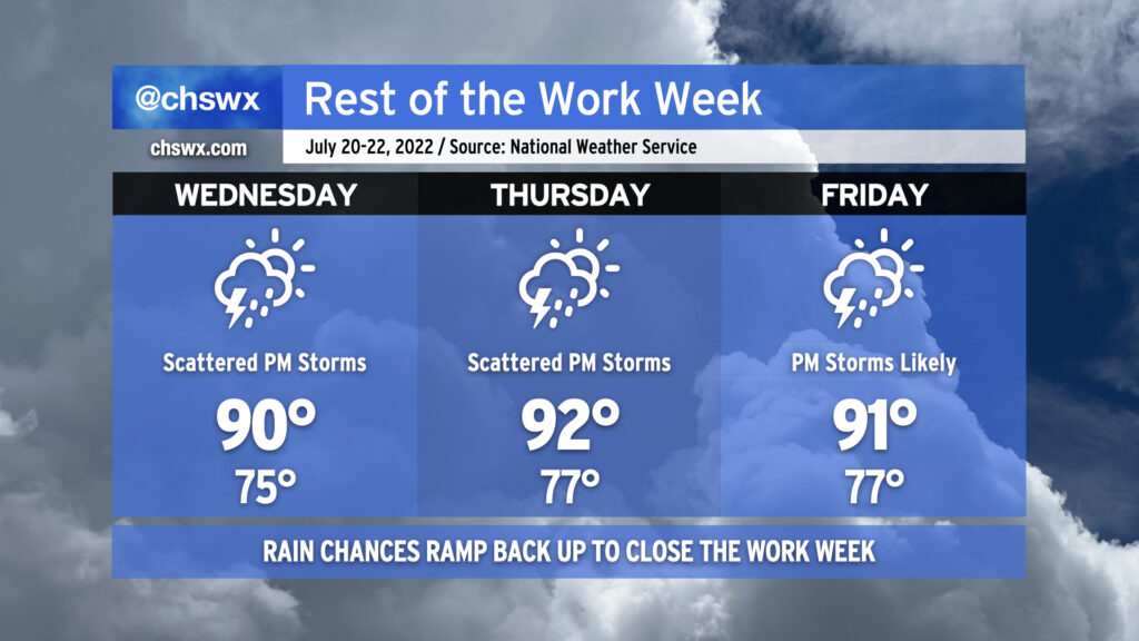
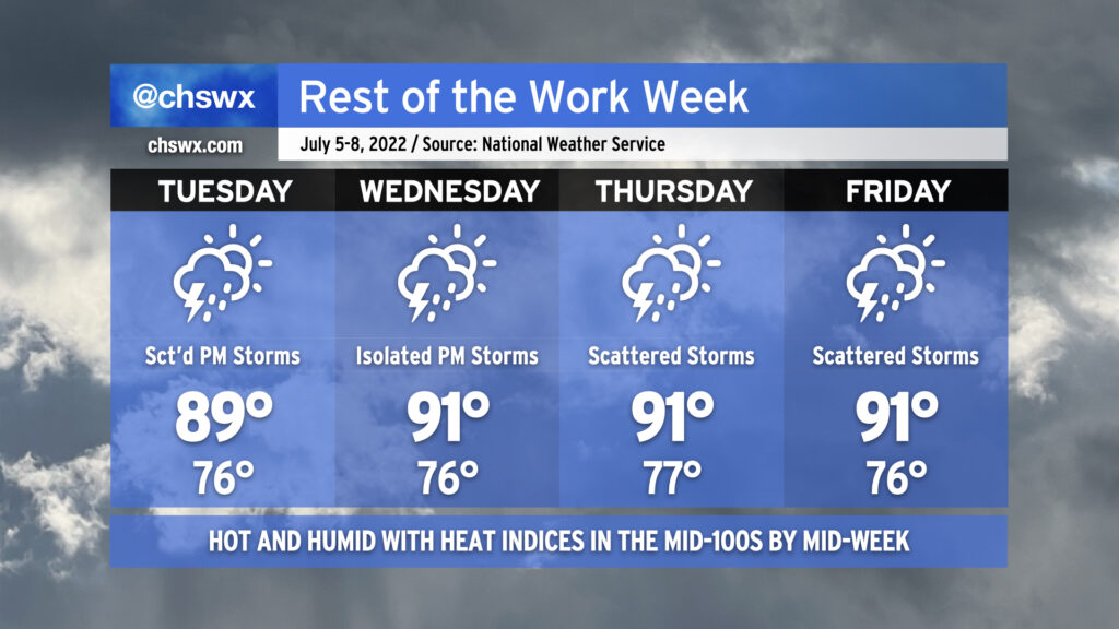
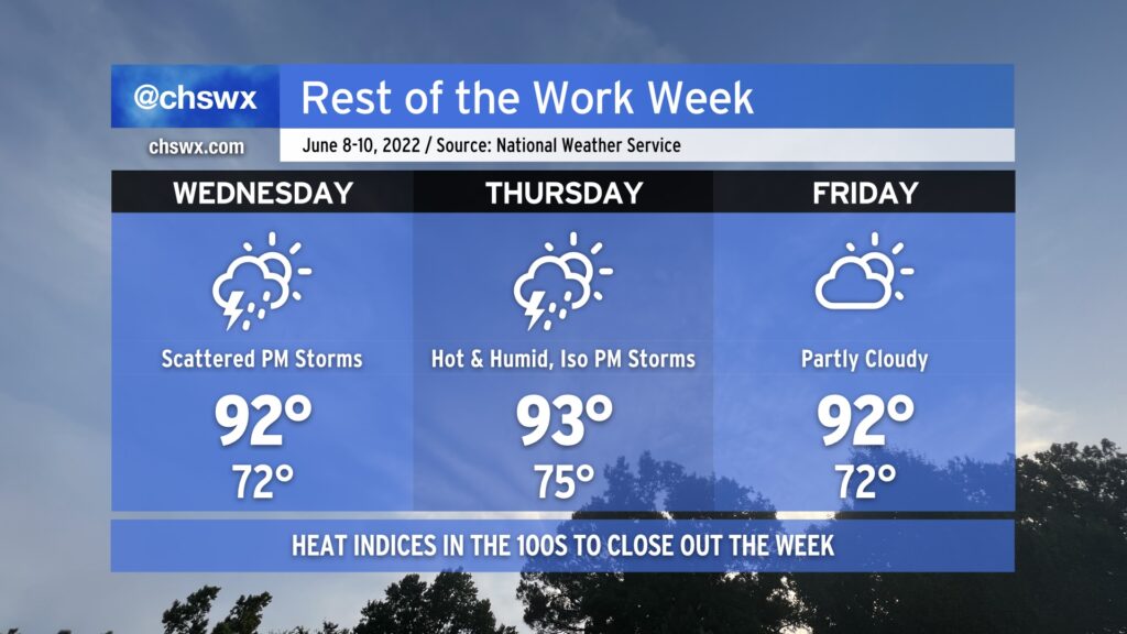
Our warm and occasionally stormy pattern stays in place of the rest of the work week as we remain under the influence of a broad trough aloft. Wednesday will yield another stormy afternoon with a low-end severe weather risk as a disturbance in the mid-levels moves across the Carolinas; if a storm turns severe, damaging wind gusts would be the main issue. Otherwise, it’s another hot and humid day — highs top out around 90° in the afternoon with heat indices once again peaking around 100-102° before storms develop and disrupt the temperature curve.
Thursday should run a little quieter with a little less mid-level energy in play, but we’ll still see the usual spate of isolated afternoon showers and thunderstorms along and ahead of the seabreeze. Temperatures will run a little warmer Thursday, with air temperatures in the low 90s and associated humidity yielding heat indices running around 105° in the afternoon. A cold front will sink southward toward the Carolinas on Friday; this will make showers and thunderstorms in the late afternoon and evening hours a little more likely. Temperatures on Friday continue in the low 90s with heat indices in the low to mid-100s.
Rain chances look to taper off as we get into the weekend, with scattered storms possible Saturday and more isolated storm coverage than we’ve seen in a little while expected on Sunday. It’ll stay muggy with lows in the mid-70s and highs in the low 90s each day.
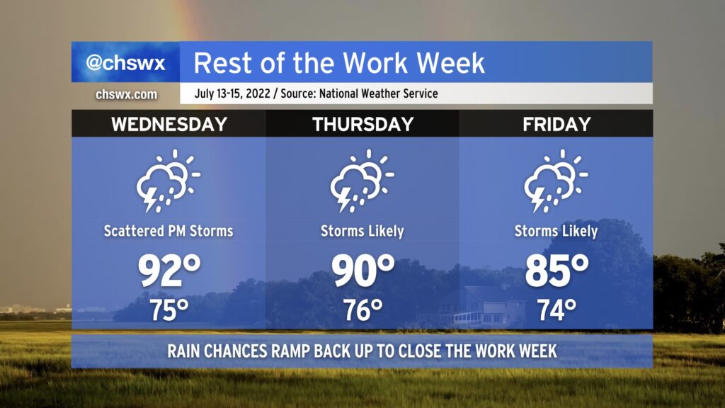
The rest of the work week will remain unsettled and turn even more so as we close it out thanks to another cold front moving into the area. Wednesday will maintain a more standard summer-like feel with highs in the low 90s and afternoon thunderstorms along and ahead of the seabreeze. By Thursday, though, we’ll start to see rain chances head back into the “likely” category once again as the aforementioned front moves in and stalls out. This’ll stick around into Friday, with perhaps even more coverage of showers and storms helping to keep highs in the mid-80s. Heavy rain continues to be a concern with any storms that fire — the atmosphere remains very juiced up — and we’ll certainly see a lightning risk with storms as well.
High tides on Wednesday and Thursday evenings will once again be capable of producing minor salt water flooding in coastal areas including downtown Charleston. We should be okay rain-wise on Wednesday, but on Thursday, we’ll want to keep a close eye on where the heavy rain is in case it coincides with the flooding high tide. Regardless of where the rain is, be ready for additional Coastal Flood Advisories from the National Weather Service.
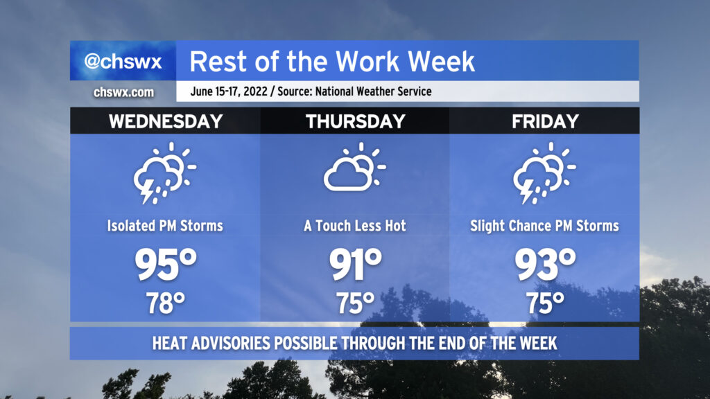
The rest of the work week will remain quite warm and steamy as a tropical airmass stays in the area for the next several days. Tuesday and Wednesday will feature more typical summertime popup showers and thunderstorms in the afternoons while heat indices soar into the 100s both days (with 105°+ heat indices possible Wednesday). As is typical, a stronger storm or two can’t be ruled out, and given the airmass in place, pockets of heavy rain could develop, perhaps causing some localized flooding. We’ll also want to keep an eye on any disturbances that develop and ride around the periphery of an upper ridge that’ll be centered to our west; both the NAM and GFS seem to be trying to sniff something out along these lines for late Wednesday/early Thursday. Only time will tell whether this is legit or not.
We’ll see an uptick in shower and storm coverage Thursday and Friday as the ridge retrogrades a little further west and atmospheric moisture increases. We could see precipitable water values in excess of 2.2-2.3″ as we close out the work week, which would be a ripe atmosphere for very heavy rain in any thunderstorms that can develop. Scattered coverage of afternoon thunderstorms appears probable. Temperatures will remain quite warm, with highs in the low 90s, lows in the mid-to-upper 70s, and heat indices probably running over 105° once again each afternoon before thunderstorms fire.
In other words: It must be July in the Lowcountry.
After some much-needed rain fell across the area — with upwards of 2-4” in many spots near the coast, particularly around Mt. Pleasant — more is in store overnight tonight into Wednesday as a stalled front continues to linger in the area. Mid-level energy will traverse the area and should initiate another round of showers and thunderstorms overnight into tomorrow morning. We’ll want to keep an eye on the risk for waterspouts again in the morning, too, though whether it’s a repeat of today’s performance remains to be seen.
The front will eventually wash out later Wednesday, but we’ll still have plenty of moisture in the area and surface triggers in the form of a coastal trough and other mesoscale boundaries to help maintain solid rain chances Thursday and Friday.
The rain will continue to keep high temperatures suppressed into the mid-80s each afternoon. Thunderstorms will certainly act as a temperature disruptor, and as a result, the timing for places to reach those highs — if they’re reached at all! — could vary widely across the Tri-County.
Moisture looks to hang around for the holiday weekend, and it’s increasingly likely we’ll at least be dodging some afternoon thunderstorms for the Fourth of July. Will continue to keep an eye on this as we get closer, but for now, the advice is to make sure you’ve got a good second, indoor option for your Independence Day festivities.
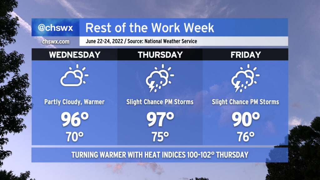
After today came in cooler than expected thanks to some cloud cover (and even a few light showers), the heat should begin to really kick back in on Wednesday as we’ll see much more sunshine than we did today. The atmosphere remains dry and capped, and that will keep afternoon shower and thunderstorm chances at bay for one more day. 70s dewpoints return in earnest for Thursday, and that combined with a 97° air temperature will drive heat indices into the lower 100s in the afternoon. We’ll also start to see the standard slight chance of afternoon thunderstorms return to the forecast Thursday. A weak front will head south across the area late Thursday into Friday, taking the edge off the higher heat for Friday with highs topping out around 90°. We’ll keep a slight chance of seabreeze storms in the forecast to close out the week.
The rest of the work week will remain hot — though not to the degree that we observed today, with the first 98° reading at the airport since August of 2019 — with only a slight chance of a thunderstorm as a strong ridge remains firmly in place across the area. Heat indices could once again reach advisory criteria tomorrow with only a slight chance of a thunderstorm to cool things off. So it will go Thursday and Friday, too, though onshore flow behind a backdoor front will keep temperatures a little “cooler” on Thursday, topping out “only” in the low 90s. Bottom line: Stay geared up for hot weather for the foreseeable future. We’ve got a little break coming Sunday, but the heat will then just surge right back as we get into next week. (Such is summer.)
Coastal flooding will continue to be an issue with the evening high tides through Friday. Onshore flow should send tidal departures even higher on Wednesday evening, with moderate flooding expected with the 9:55 PM high tide. Expect scattered to potentially numerous road closures in downtown Charleston tomorrow evening as a result, though thankfully after the commute.
Everyone break out the fanny packs…the 90s are back! We’ll get back there tomorrow afternoon with an uptick in moisture as well; before thunderstorms develop along the seabreeze in the afternoon, we’ll see heat indices approach 100°. We could very well breach the century mark Thursday afternoon, too. Ever-so-slightly drier air might keep heat indices a little more in check on Friday based on this evening’s guidance, but we’ll see how that ultimately goes based on the positioning of a stalling front.
Wednesday and Thursday will both generally feature the standard round of afternoon showers and thunderstorms, aided a bit by some upper-level help. We could even see some additional thunderstorms move into the area Wednesday evening as a disturbance moves by. A couple of Wednesday’s thunderstorms could be on the strong side, too, with damaging wind gusts and large hail the main concerns. Right now, Friday is looking a bit drier, but that will be governed by how far south high pressure can wedge into the area. Stay tuned for fine-tuning on that one.
As we head into the weekend, we could see another round of active weather on Saturday as another front heads into the area. This will be the best chance of rain for the next few days as high pressure builds back into the area on Sunday. Drier air moving in will make for a reasonably nice day on Sunday (though highs look to still top out around 90°), but more importantly, it increasingly looks to be a rain-free day, which is excellent news for the Spoleto finale.