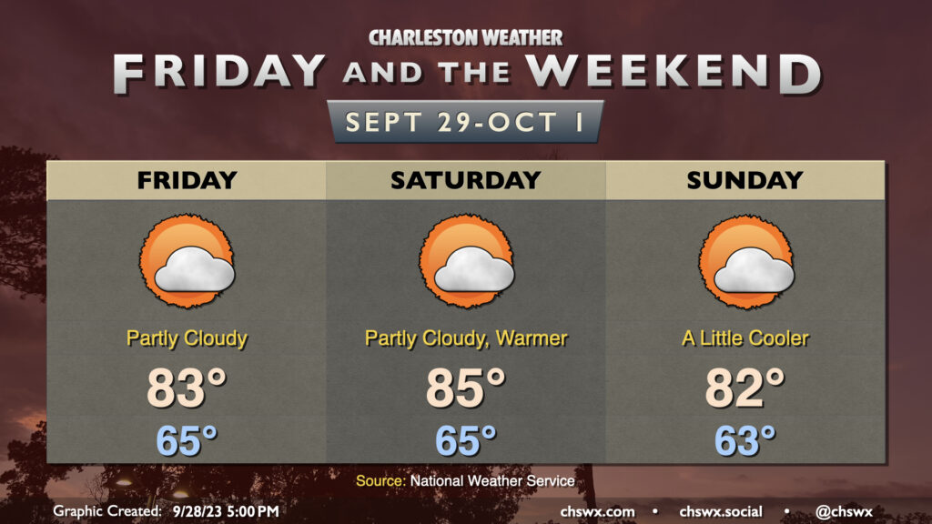
A stalling cold front and a cutoff low aloft will combine to bring shower and storm chances back to the area starting Friday afternoon, peaking on Saturday, and then gradually tapering on Sunday. Highs on Friday top out in the low 90s, with the best chance for showers and thunderstorms generally being found along and ahead of the seabreeze. With the upper low drifting across the area Saturday, showers and thunderstorms could fire at any point, with some guidance hinting at Saturday getting off to a bit of a soggy start as showers and thunderstorms drift inland. Highs on Saturday top out in the mid-to-upper 80s given the rain and cloud cover. We’ll see the upper low lift out of the area on Sunday, decreasing the risk of showers and storms somewhat, but coverage should still be decent given the nearby front.
We have one more rain-free and rather warm day coming up on Thursday. Expect highs to once again top out in the mid-90s under partly cloudy skies, with some humidity mixing in to drive heat indices to the upper 90s to around 100°. It’s worth noting that the NWS forecast high of 95°, if it did indeed come to pass, would tie the daily high temperature record set in 1941 and then tied in 1947 and 2019. (For reference, last year’s high on September 7 topped out a degree shy of the record.) Ridging will weaken throughout the day, but much of us should expect to get the day in rain-free. I don’t know that I’d totally rule out a shower or storm closer to I-95, though.
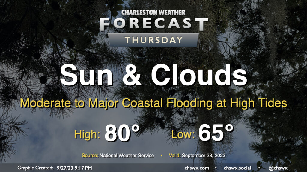
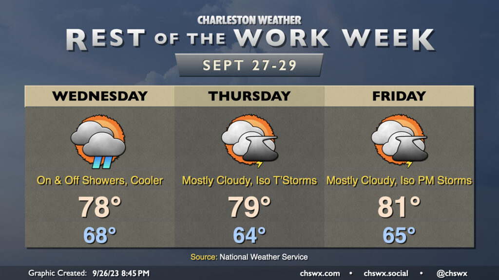
The forecast for the rest of the work week is generally on track: Temperatures in the mid-90s will continue through Thursday with peak heat indices around 100° thanks to some, but not too much, humidity. Skies will generally run partly cloudy to mostly sunny. Storm chances don’t return to the picture until Friday, and even then, it looks like coverage will be more on the isolated side. The weaker ridge will keep temperatures running a little lower (low 90s) on Friday, but above-normal temperatures look to continue heading into the weekend despite steadily increasing storm chances as a front arrives and stalls out nearby. (Remember, normal is looking a little lower these days: normal highs for this week generally run around 87°.)
Plenty of sunshine is in the offing for the rest of the work week as high pressure remains the primary driving force for our weather. Temperatures climbed back into the low 90s on Labor Day, and this will continue as we head into the rest of the week, with mid-90s expected by mid-week. Dewpoints in the mid-60s will keep heat indices in the mid-90s on Tuesday, but as dewpoints creep up throughout the week, so it shall be with the heat index as well. Feels-like temperatures will be flirting with 100° again starting Wednesday through the rest of the week.
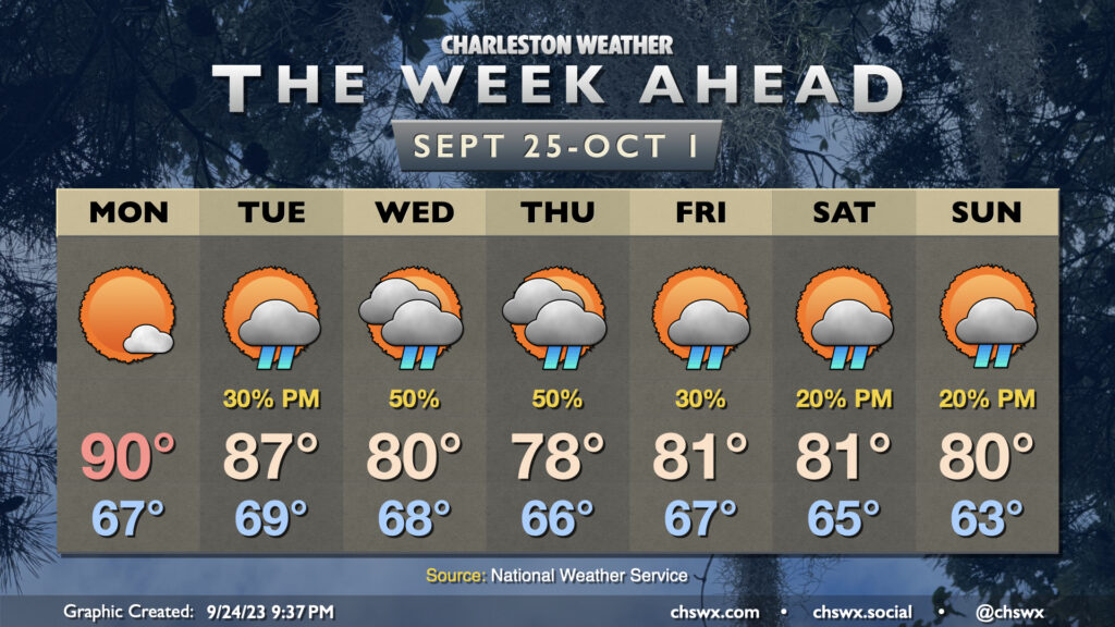
There’s not much in the way of rainfall to report on for much of the week with high pressure in control, but we start to see some cracks in the armor on Friday as a few storms should pop on the seabreeze, with slightly better coverage of showers and storms each afternoon this weekend.
Hurricane Idalia, which as of this writing was a strong Category 2 hurricane with 100 MPH maximum winds, will make landfall as a major hurricane in Florida later Tuesday or early Wednesday. From there, Idalia will turn more northeast, bringing heavy rain, gusty winds, coastal and freshwater flooding, and the risk for a tornado or two within rain bands to the area later Wednesday into early Thursday morning. Trends have been for the storm to track a little more inland of the coast than we’ve seen forecasted in the past day or so, and there is pretty good agreement that this will be the case, expanding the heavy rain threat further inland along with the tornado threat in the evening. Here’s a full rundown of what to expect.
Tuesday will be another warm and muggy day as we prepare for Idalia’s arrival in the Lowcountry. We start the day in the mid-70s and warm to around 90° with heat indices approaching 100° within the increasingly tropical airmass. Showers and thunderstorms should begin to fire along the seabreeze in the afternoon and become somewhat numerous at times. Heavy rain capable of minor flooding will be possible. We’ll also need to watch the risk for coastal flooding in the evening, with minor to moderate flooding possible as water levels approaching 7.5′ with the 7:31 PM high tide. Due to the Storm Surge Watch in effect, there will be no Coastal Flood Advisory, so keep that in mind.
Much of the weather scuttlebutt this week will be about Tropical Storm Idalia, which increasingly looks like it’s going to have impacts on the area Wednesday into Thursday. We have a couple reasonably quiet days ahead before the weather begins to head downhill later Tuesday night. Expect highs on Monday to top out in the low 90s with just a slight chance of an afternoon shower or thunderstorm along the seabreeze; it’ll be a similar story for a good bit of Tuesday before moisture from Idalia potentially triggers a predecessor rain event along and ahead of a stalled front, which could bring very heavy rain to some spots and maybe even some flooding ahead of the storm’s arrival.
Sunday will be yet another warm and muggy late-August day across the Lowcountry. We’ll start the day in the mid-to-upper 70s before highs head to the low 90s in the afternoon. Heat indices should peak in the low 100s. From there, we should see a scattering of showers and thunderstorms along and ahead of the seabreeze. We may also see some activity from the north near a stalling cold front trying to infiltrate the area as well. The strongest storms will be capable of heavy rain and gusty winds, though widespread severe weather is far from in the cards. Overall, no washout of a day, just be ready to move outdoor activities inside if storms approach.
Saturday will be the peak of this stretch of hot weather as temperatures head to the mid-90s in the afternoon (though not quite as high as forecast earlier this week…good thing, too). Heat indices will get close to 109-110° in the afternoon. There’s no heat advisory as of this writing, and if trends continue, we’ll probably fall just short of criteria. Still, these kinds of heat indices still increase the risk for heat illness, so be getting plenty of water if you’re going to be exerting yourself outside in the afternoon. We should see a few storms fire along the seabreeze in the afternoon, which will bring some relief to a few of y’all.
More widespread showers and storms are expected Sunday (though not a complete washout, either) as a front sags southward and stalls out nearby. It’ll be another warm and humid day with air temperatures topping out in the low 90s and heat indices 100-103° before thunderstorms fire off and cool things down somewhat. The unsettled weather will continue into next week as the front hangs around and plays a big role in our weather.
Alas, Friday and the weekend will bring us back to reality a little bit after a couple fairly nice days for late August. Highs on Friday top back out in the mid-90s under mostly sunny skies as ridging holds on tight for at least one more day, suppressing afternoon thunderstorm chances (and, as such, any chance for relief). Heat indices look to peak around 102° or so — not quite advisory level, but not exactly pumpkin spice weather, either.
Saturday will be even hotter, as air temperatures head up into the upper 90s. Combine this with solidly mid-70s dewpoints and that’ll yield heat indices approaching the heat advisory threshold of 110°. As ridging aloft begins to weaken, the seabreeze may have a slightly easier time popping a storm or two, though coverage will continue to be primarily isolated in nature.
Storm chances tick up fairly decently for Sunday afternoon and evening as a front approaches the area and a trough sets in aloft. It’ll still be hot — expect mid-90s highs before storms kick in — and heat indices could still head north of the 105° danger zone (but should remain shy of advisory thresholds). This will usher in a more active period heading into next week, with rain chances becoming more likely as the aforementioned front stalls and hangs around for a few days.