Friday & the weekend: Turning warmer, with a couple dry days
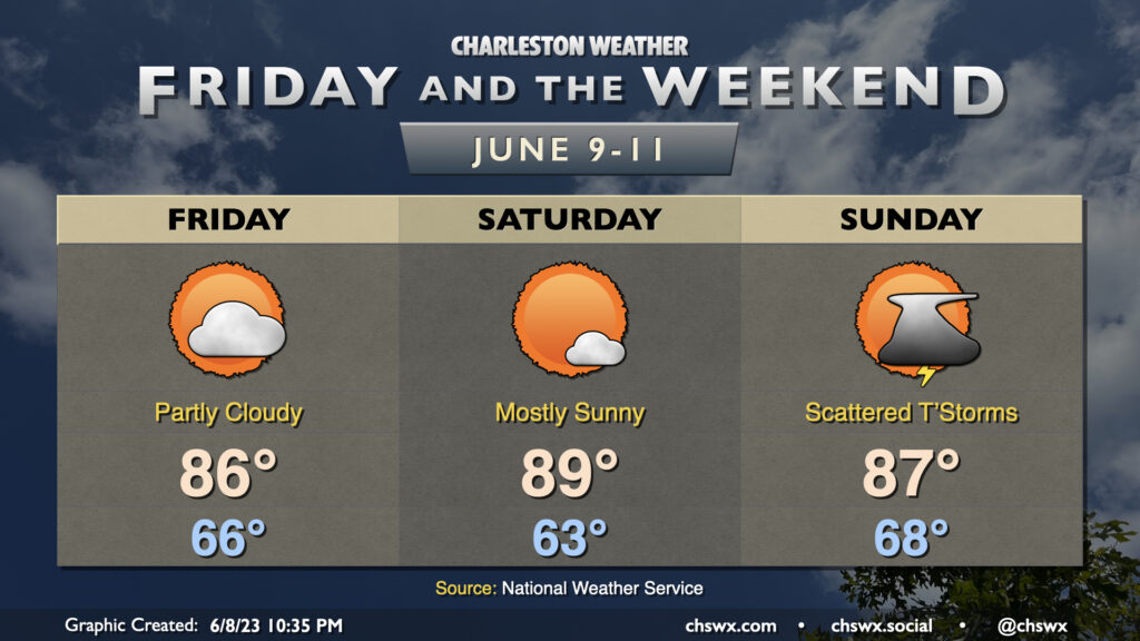
Quieter weather continues as we head into Friday and Saturday, with the risk for thunderstorms returning Sunday afternoon and evening as another front gets close to the area.
Read more »Quieter weather continues as we head into Friday and Saturday, with the risk for thunderstorms returning Sunday afternoon and evening as another front gets close to the area.
Read more »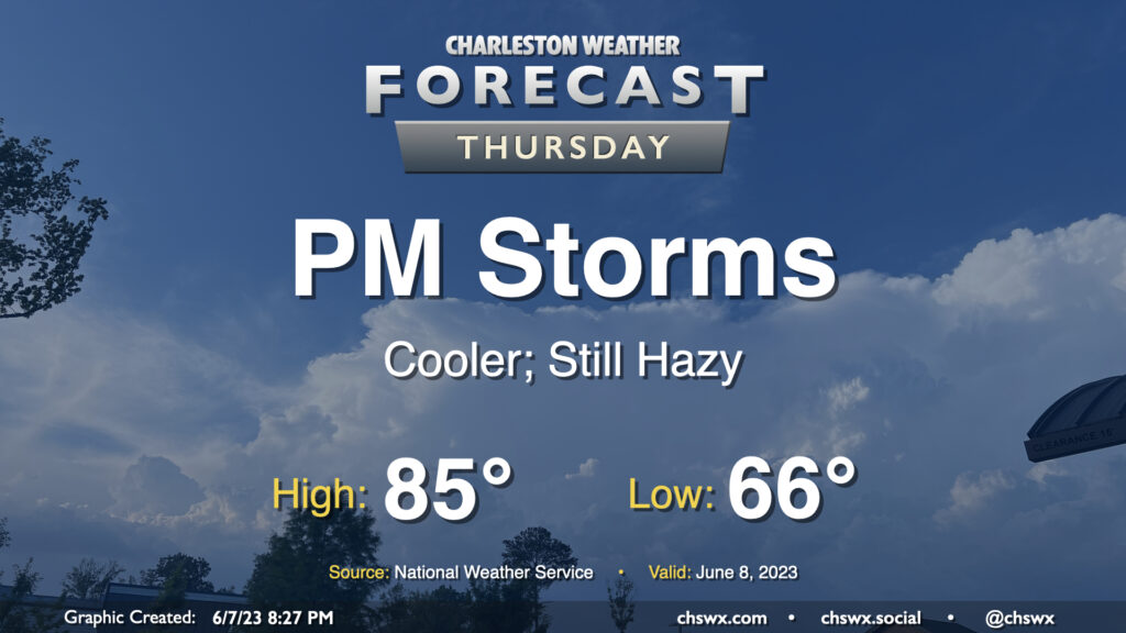
Our string of stormy afternoons looks to continue on Thursday as a cold front slowly moves through the area. Showers could fire as early as mid-morning, but the better chance of thunderstorms arrives in the afternoon and evening hours as we get some daytime heating in place. Much like the past two days, a few storms could produce gusty winds and hail, so be on the lookout for quickly changing weather conditions and be ready to move indoors quickly if storms approach.
With the front in the area, highs will top out somewhat lower than Wednesday’s 92° — expect generally mid-80s across the region before thunderstorms fire in the afternoon. We could run a little warmer — or cooler — depending on how fast the front gets south of here. (That could also modulate our thunderstorm chances a bit, too.)
Finally, there are no air quality concerns with the ongoing wildfire smoke that is being transported south into the eastern United States from Quebec, though we will continue to see a milky haze in the sky, which should persist into the weekend.
Read more »
The summertime feel continues into Wednesday, as temperatures look to top out in the low 90s in the afternoon before thunderstorms develop once again in the afternoon thanks to a combination of the seabreeze and a backdoor front that slowly approaches the area throughout the day. A few stronger storms are possible with gusty winds and hail, so be on the lookout if you have evening plans to celebrate getting over the hump.
Read more »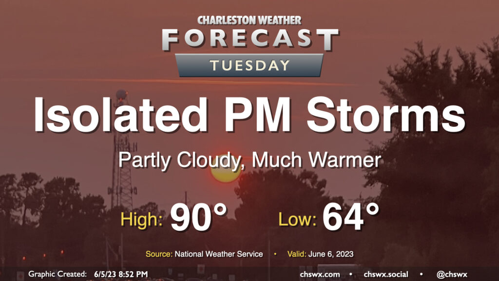
June makes a triumphant return on Tuesday as high pressure slips offshore and winds go southwesterly, transporting more warm and humid air into the area. Temperatures should reach 90° after a mid-60s start under partly cloudy skies. We should see a few isolated storms pop up in the afternoon as the seabreeze makes its inland trek. A strong pulse storm with gusty winds and maybe even a little hail can’t be totally ruled out given decent instability; this will be most likely near outflow boundary collisions.
There will be a risk of some minor coastal flooding around the 10:58 PM high tide, but the westerly component to the wind will make this a much more limited threat compared to the past few days. Still, watch for some salt water around the Citadel and on Lockwood late Tuesday evening.
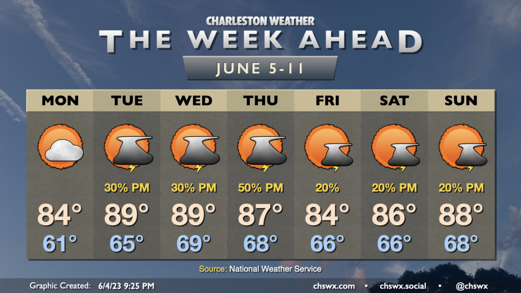
After a prolonged period of below-normal temperatures (not that a lot of us are complaining, mind you), temperatures will begin to feel a little more like June at times this week as the series of cool high pressure wedges takes a little breather. The warming trend starts Monday, as highs top out in the mid-80s — still a little below normal, but much closer than we saw on Sunday with a high of only 75°. Skies will be partly cloudy to mostly sunny, another nice change from Sunday’s generally overcast disposition.
Read more »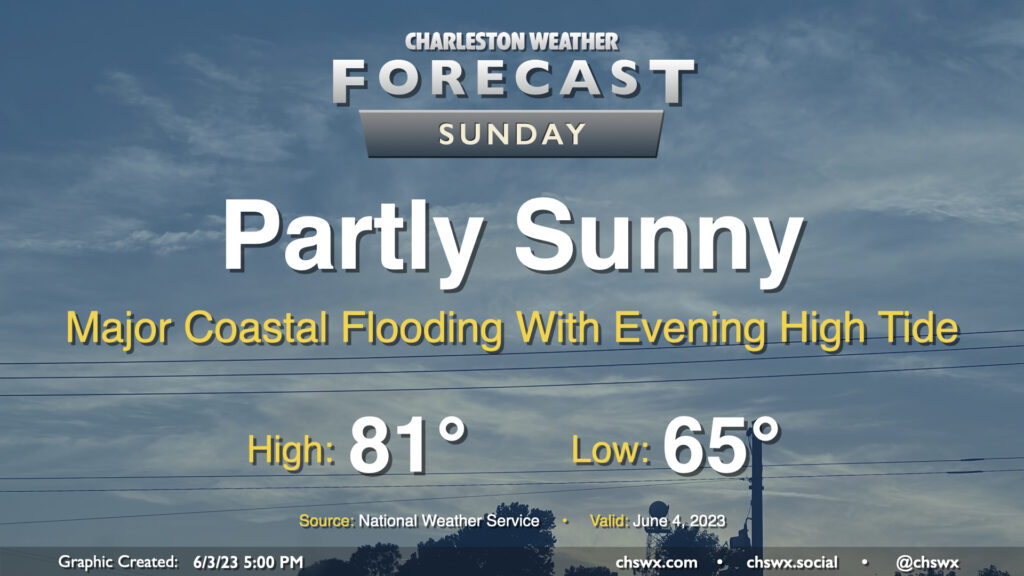
A cold front will move through the area early Sunday, which will cap highs in the low 80s — well below normal for early June in the Lowcountry. We’ll see a mix of sun and clouds as high pressure wedges in from the northeast, but rain is not expected with the drier airmass filtering in. It’ll be a little breezy — gusts 20-30 MPH will be possible out of the northeast, especially at the beaches and on elevated surfaces such as the bridges.
The main weather concern for Sunday revolves around coastal flooding. A water level over 8′ is expected once again with Sunday evening’s high tide, which peaks around 9:10 PM. This will produce major coastal flooding once again, closing numerous roads in downtown Charleston and potentially causing disruptions on barrier islands as well. This degree of flooding is extraordinarily rare for June, with only three major flooding events on record — once in 1982 and twice in 2009. Be ready to use alternate routes if you are out and about Sunday evening.
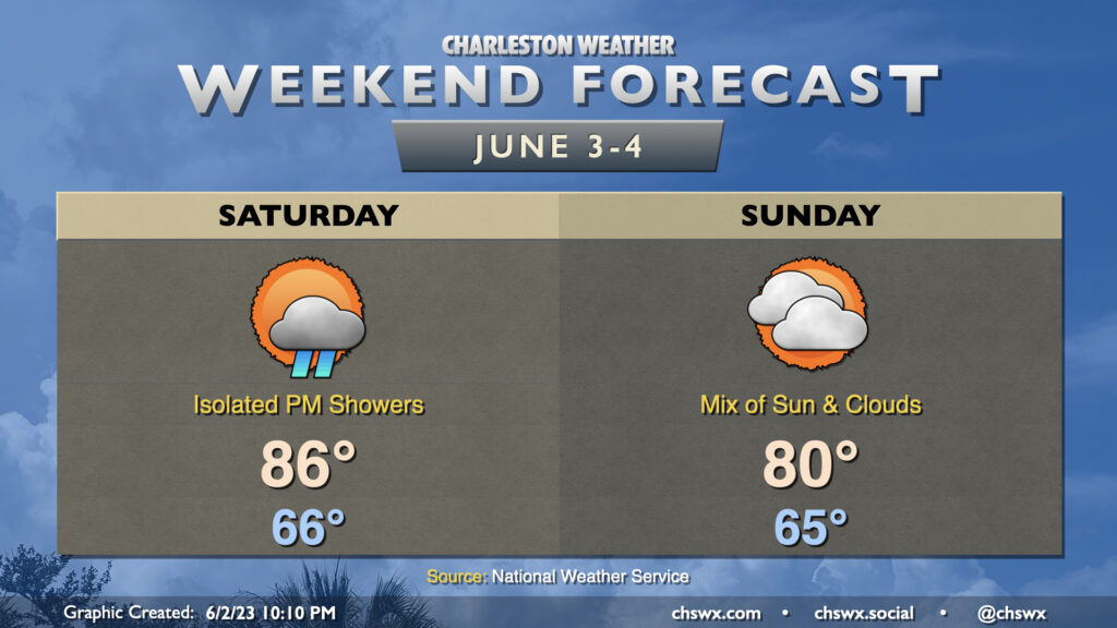
This weekend’s forecast is looking pretty good by 2023 standards, and will certainly be a far cry from what last weekend looked like. Saturday will be the warmer of the two days with highs topping out in the mid-80s in the afternoon. A few showers will be possible along the seabreeze, but those should be few and far between. A cold front moves by overnight Saturday into early Sunday morning, which will usher in some cooler and drier air that’ll keep highs capped around 80° in the afternoon under a mix of sun and clouds. Watch for some breezy conditions in the wake of the front on Sunday, with gusts near 30 MPH possible particularly on elevated surfaces and at the beaches.
Read more »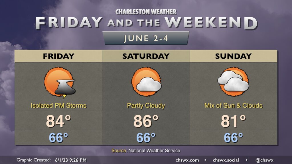
This weekend’s weather looks closer to what we wish we had last weekend. Expect highs to run generally in the mid-80s on Friday and Saturday. A cold front pushes through later Saturday, and this will drive highs a little cooler on Sunday as a result — generally topping out in the low 80s. We’ll start each day squarely in the mid-60s. Overall, these temperatures are below normal for the start of June.
This might be one of the quieter weekends we’ve had rain-wise this far this year. A stray shower or storm is possible Friday afternoon and evening, with lower chances Saturday and Sunday. We’ll see how this evolves, but this might be as close as we’ve gotten to a rain-free forecast for a weekend since early February! Stay tuned.
If you’re looking for a more authentic June feel, highs in the upper 80s look to return to the weather picture — at least briefly — by the middle of next week.
Read more »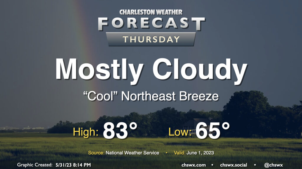
Thursday’s forecast is quiet and a little cool for this point in the year as we kick off climatological summer on June 1. Temperatures will generally run a couple degrees below normal on Thursday as cloud cover and a northeast breeze helps to keep things a little on the “cool” side. (Quotes around “cool” because it’ll still be warm and a little muggy, too.) As is customary for June, a shower can’t be totally discounted within this regime, but the vast majority of us get the day in rain-free.
Read more »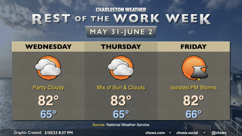
The forecast for the rest of the work week is pretty straightforward: a mix of sun and clouds each day, with temperatures starting the day around normal before topping out a few degrees below normal each afternoon. Highs will generally run in the low 80s after starting each day in the mid-60s, somewhat unusually “cool” for the end of May and beginning of June. Precipitation chances will be minimal Wednesday and Thursday, with a slight chance of an evening thunderstorm on Friday.
Read more »