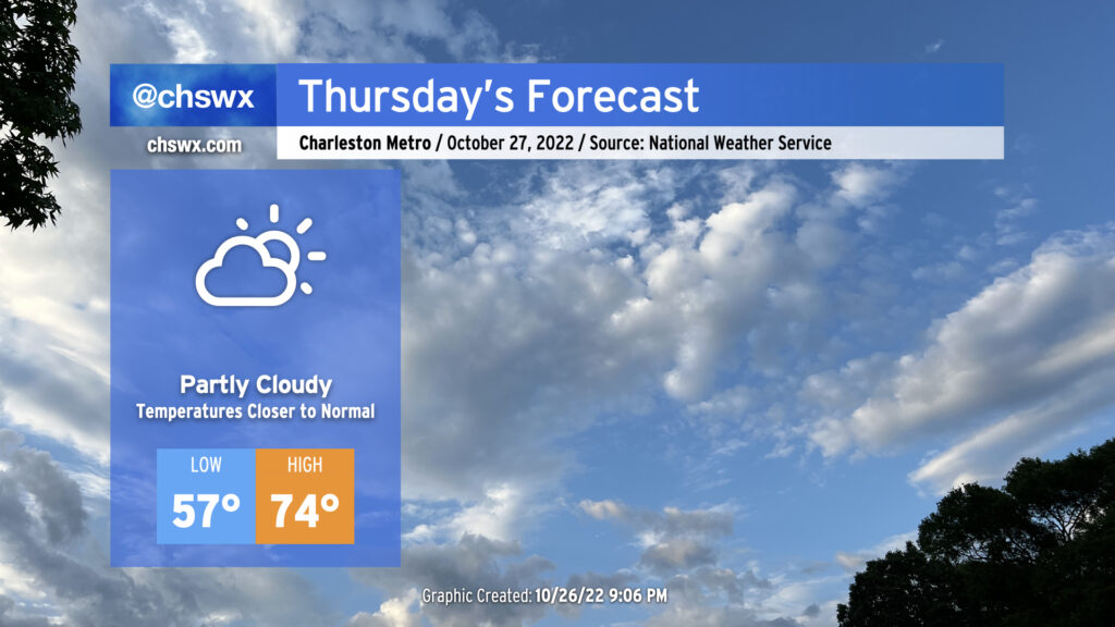
A cold front is on its way through this evening, which will bring cooler temperatures for Thursday and beyond after highs peaked in the low 80s this afternoon away from the locally cooler coastline. Winds will go to the north and then the northeast overnight as high pressure builds in from the north and west. We’ll generally see scattered clouds throughout the day with those northeast winds keeping us about 5-7° cooler than we saw Wednesday. The aforementioned northeasterly winds and upcoming lunar perigee will contribute to another risk for minor to moderate coastal flooding around the 9:47am high tide, so be aware of the potential for closed roads once again tomorrow morning (though the peak of any tidal flooding should miss the bulk of any commute time at this point).
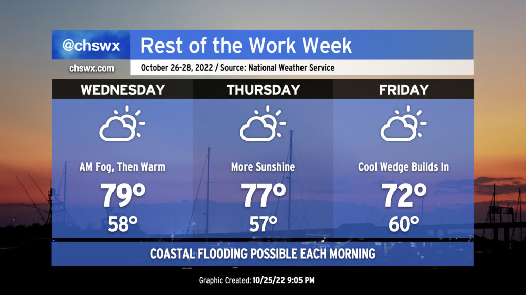
We look to get off to another foggy start Wednesday morning, at least in spots, as temperatures bottom out just shy of 60° in the morning. We may not see quite the density nor the duration that we saw Tuesday morning, but still, be ready to use those low beams and allow extra time to get where you are going. Once any fog burns off, warm advection ahead of a cold front will help temperatures get to near 80° in the afternoon under partly cloudy skies.
The front gets through late Wednesday. It looks like it’ll get through mostly rain-free given limited moisture. Once that happens, winds will go around to the north and northeast and begin to bring some cooler air into the area. The persistent northeast winds will cool things down even further for Friday as highs only top out in the low 70s as cloud cover builds within a strengthening wedge of high pressure.
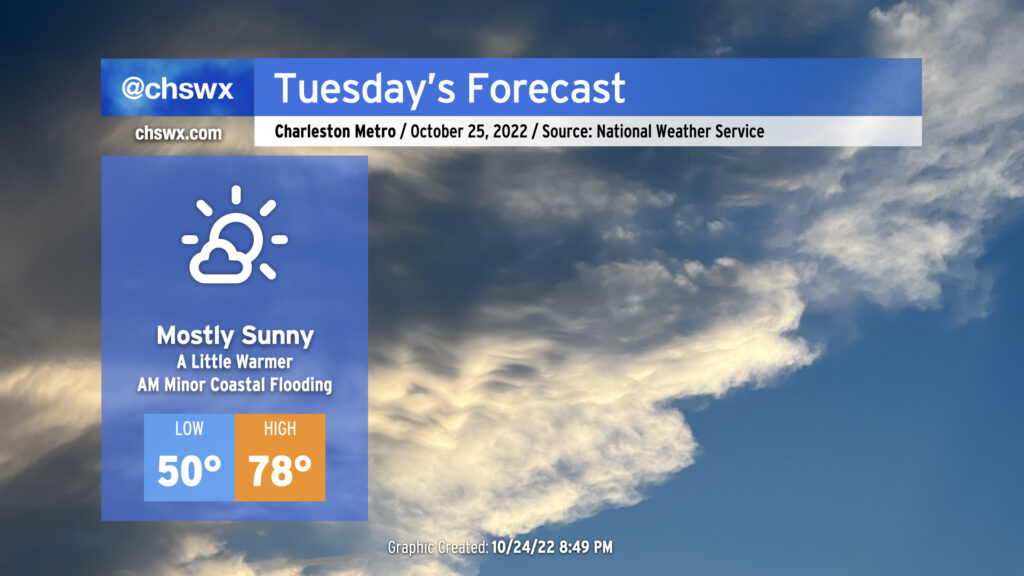
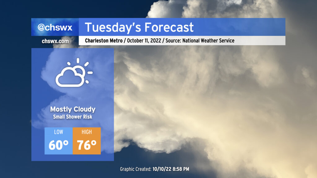
We’ll continue our warming trend on Tuesday ahead of a weak front that’ll come through later Wednesday. After starting around 50° thanks to clear skies and light winds, we’ll warm well into the upper 70s in the afternoon. We should see mostly sunny skies for a good bit of the day, with some higher clouds beginning to thicken later on. Rain-free conditions continue, and it should overall be another good day of weather across the area.
The only weather hazard of note will be the risk for some minor coastal flooding around the 8:20 AM high tide. Right now, water levels are forecast to peak around 7.1-7.3′ in the harbor, which will be enough to perhaps close a couple of the more vulnerable roads on the Charleston peninsula (such as around Hagood and Fishburne as well as near the City Market).
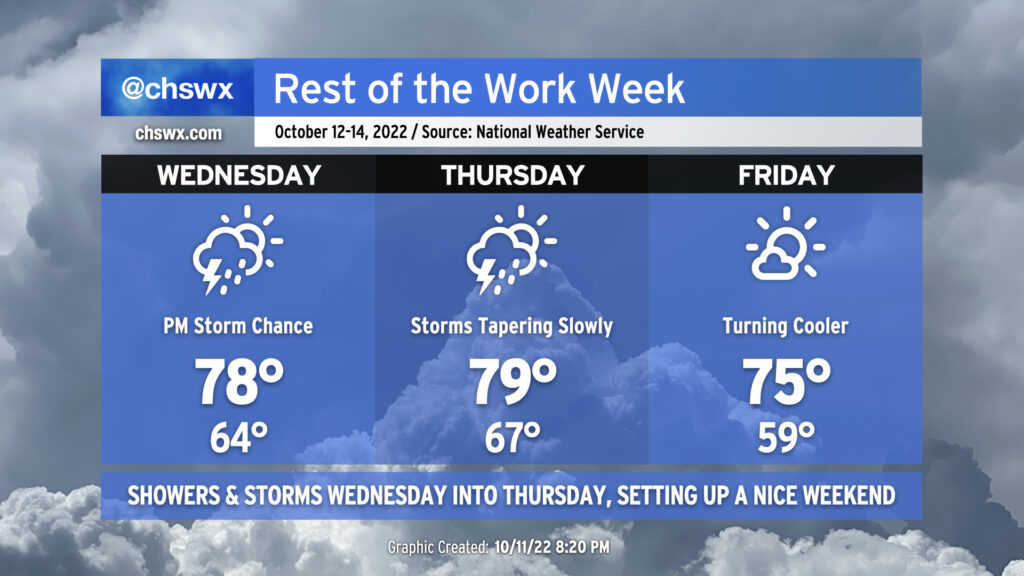
The weather will take a turn more toward unsettled starting Wednesday afternoon as some upper-level energy well out ahead of a cold front helps to induce some showers and thunderstorms across the area.
Wednesday will start fairly mild with lows in the mid-60s thanks to persistent cloud cover. Winds will stay onshore, but despite this, we should still top out solidly in the upper 70s in the afternoon ahead of thunderstorms. It certainly seems that we may get a majority of the day in rain-free, with rain chances starting to head up around commute time.
The greatest risk for showers and thunderstorms looks to be after sunset through early Thursday morning. It’s likely we’ll get a good bit of Thursday morning in rain-free, allowing highs to top out near 80° in the early afternoon. Then, it’s possible that some showers may redevelop ahead of the cold front itself as its timing should coincide with peak heating. The front gets through Thursday evening, and by Friday, we’re starting out quite a bit cooler — upper 50s as opposed to mid-to-upper-60s — with highs topping out in the mid-70s under quite a bit of sunshine. This will set up a beautiful weekend of weather with plenty of sunshine and comfortable temperatures, though perhaps not quite as cool as mentioned yesterday. Still, though, mid-to-upper 70s remain below normal for highs for this point in October.
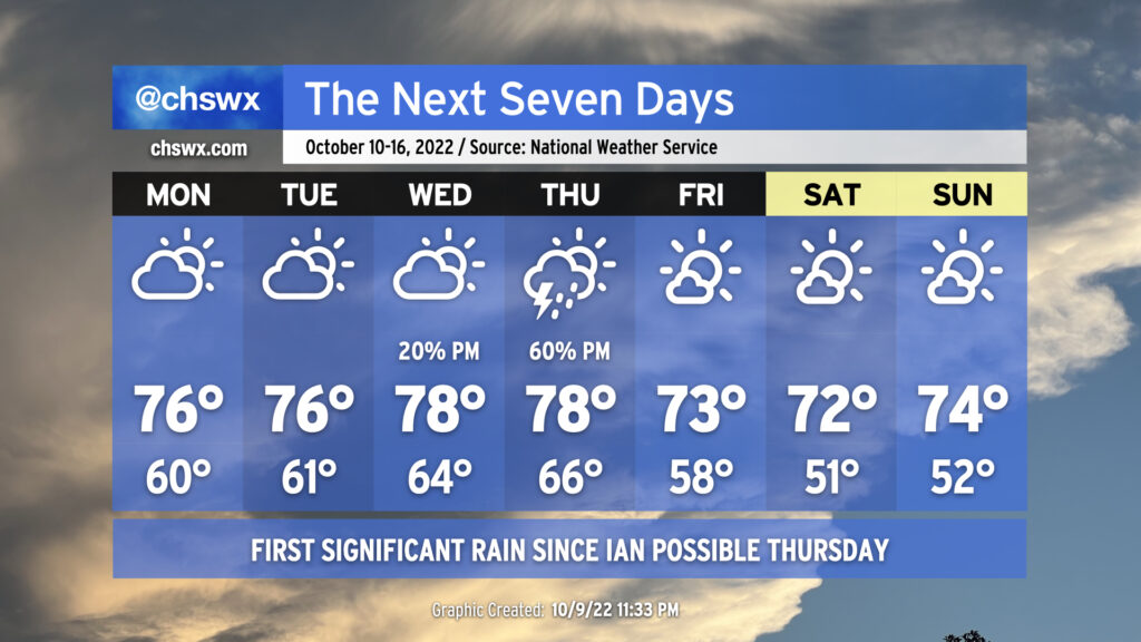
Not much weather to write home about for Tuesday as we get one more mostly dry day in ahead of a cold front which should bring the most substantial rain since Ian to the area for later Wednesday into Thursday. Cloud cover blanketing the area will help keep lows elevated to around 60° to start the day. Breezy onshore winds and continued cloud cover will keep high temperatures capped in the mid-70s. Much as we saw today, there is a small chance of a shower or two in the afternoon, but these won’t be horribly disruptive and should be short-lived if they do end up firing.
Another round of minor to moderate coastal flooding will be possible a couple hours around the predicted 9:40am high tide. Be ready to use alternate routes in case of flooded or closed roads in downtown Charleston.
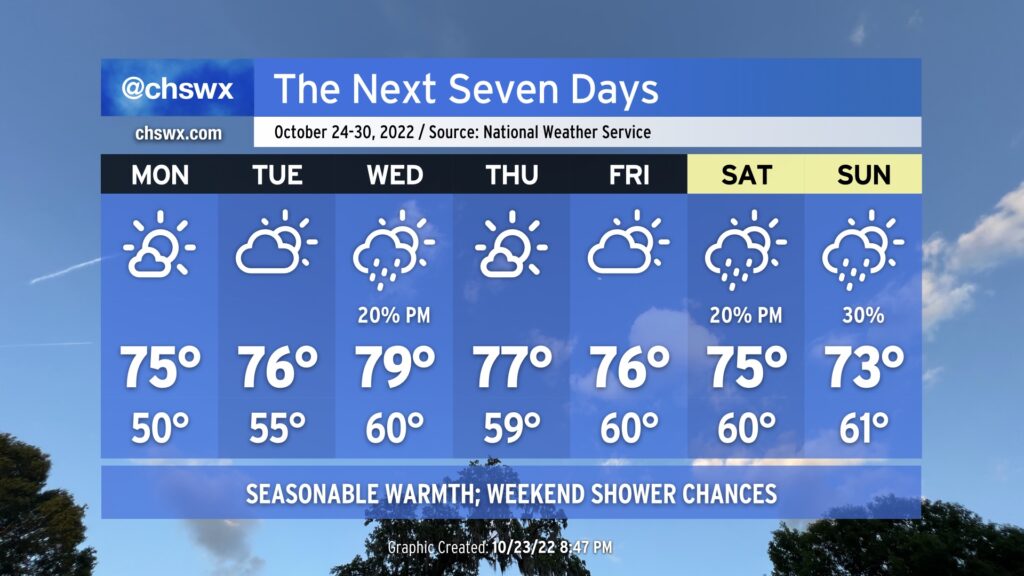
On balance, the week ahead will be primarily quiet weather-wise, with the exception of Thursday as a cold front presses through the area, bringing along some showers and thunderstorms. Highs through Thursday will remain a little below normal, generally running in the mid-to-upper 70s. Conversely, cloud cover and increased moisture will keep lows at or a little above normal through Thursday morning, with lows in the mid-60s expected Wednesday and Thursday right ahead of the front.
The weather on Thursday could bear watching for a few stronger storms depending on how much instability can develop. We’ll have good wind shear in place, but the instability — as is often the case as we head into the cool season — is going to be the main question mark. More likely, though, Thursday will represent the first significant rain for the area since Hurricane Ian, though amounts certainly won’t approach Ian-like numbers.
Once the front is through, we will see cloud cover decrease and temperatures once again head well below normal for Friday and the weekend, which is looking pretty good. Highs through this period will run in the low 70s, while lows will bottom out in the upper 50s Friday and the low 50s Saturday and Sunday, several degrees below normal for this point in the year.
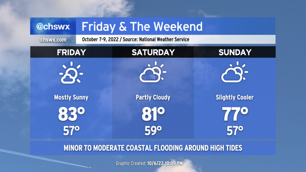
We stay seasonably warm for Friday & the weekend, even with a cold front swinging through later Saturday. Friday’s going to be the warmest day of the set with the most unencumbered sunshine and some compressional heating ahead of the cold front helping to drive highs to around the low to mid-80s. A few more clouds will mark the approach and passage of the front Saturday, but no rain is expected; expect temperatures back in the low 80s ahead of the front Saturday afternoon. Winds go northeasterly on Sunday and will help to cool things down a touch. Expect highs to run in the upper 70s, generally a few clicks below early-to-mid-October normals, but not quite the chill we saw in the immediate wake of Ian last week.
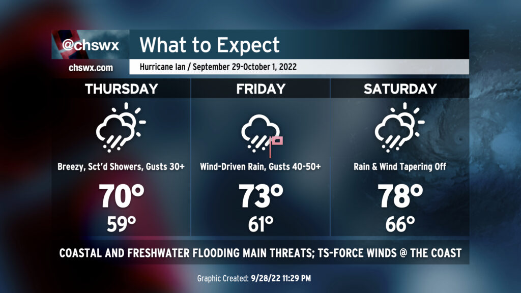
We are breezy but rain-free this evening as dry high pressure remains in control of our weather. It will hang on for a bit for the first part of Thursday, but a gradual deterioration in weather will begin in the afternoon. It’s a good time to finish gathering supplies for a rough period of weather beginning later Thursday through Saturday morning.
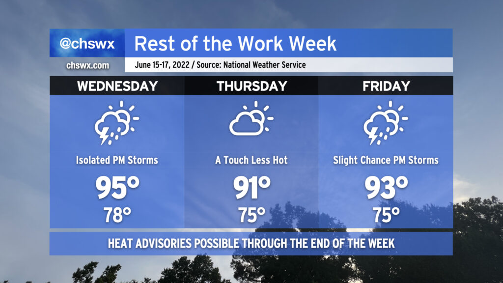
The rest of the work week will remain hot — though not to the degree that we observed today, with the first 98° reading at the airport since August of 2019 — with only a slight chance of a thunderstorm as a strong ridge remains firmly in place across the area. Heat indices could once again reach advisory criteria tomorrow with only a slight chance of a thunderstorm to cool things off. So it will go Thursday and Friday, too, though onshore flow behind a backdoor front will keep temperatures a little “cooler” on Thursday, topping out “only” in the low 90s. Bottom line: Stay geared up for hot weather for the foreseeable future. We’ve got a little break coming Sunday, but the heat will then just surge right back as we get into next week. (Such is summer.)
Coastal flooding will continue to be an issue with the evening high tides through Friday. Onshore flow should send tidal departures even higher on Wednesday evening, with moderate flooding expected with the 9:55 PM high tide. Expect scattered to potentially numerous road closures in downtown Charleston tomorrow evening as a result, though thankfully after the commute.