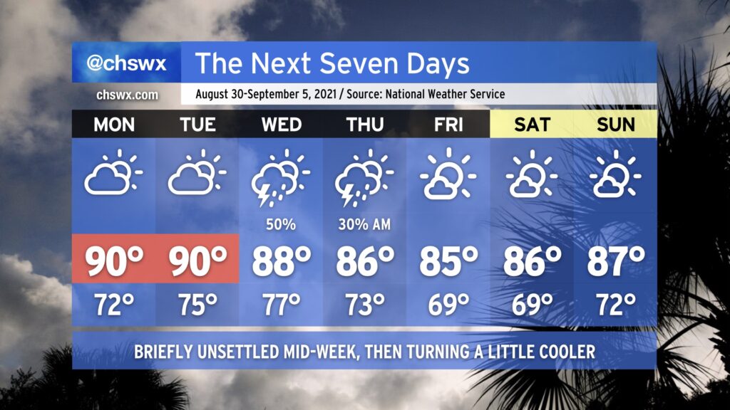
On balance, the week ahead actually looks pretty good. Rain-free but warm conditions (highs ~90°) continue Monday and Tuesday as the ridge of high pressure remains in place across the region. By Wednesday, a cold front and a slug of moisture at least partially sourced from the remnants of Hurricane Ida push southward across the area, scattering showers and thunderstorms across the metro area. The front should clear the area by Thursday, yielding partly cloudy skies and somewhat cooler temperatures with less humidity as we head into the weekend — the first weekend of meteorological fall, which runs from September 1-November 30.
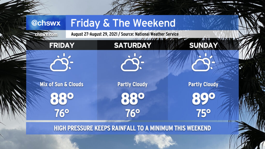
High pressure will continue its influence on our weather as we head into the final weekend of August. Temperatures look to remain in the upper 80s to around 90° each afternoon with warm starts in the mid-70s away from the coastline, where temperatures continue to struggle to get below 80° each morning. The aforementioned high pressure will act to keep shower and thunderstorm activity to a minimum through the weekend, certainly welcomed considering how soggy of an August we’ve had.
High pressure will also keep Tropical Storm Ida, forecast to become a hurricane as it approaches the central Gulf Coast this weekend, out of our hair. Unfortunately, it looks to be another direct strike on Louisiana, an area that is very tropical-cyclone weary after the numerous storms it dealt with last season. If you have friends or family there (as well as in coastal Mississippi and Alabama), please make sure they understand that time is of the essence to prepare as tropical storm-force winds could begin as soon as Saturday evening along the coast. Ida is forecast to make landfall sometime Sunday evening along the Louisiana coast. From there, its moisture may get caught up in a frontal system and help provide the juice for another round of wet weather here next week.
For now, though, enjoy a relatively quiet weekend of weather in our neck of the world.
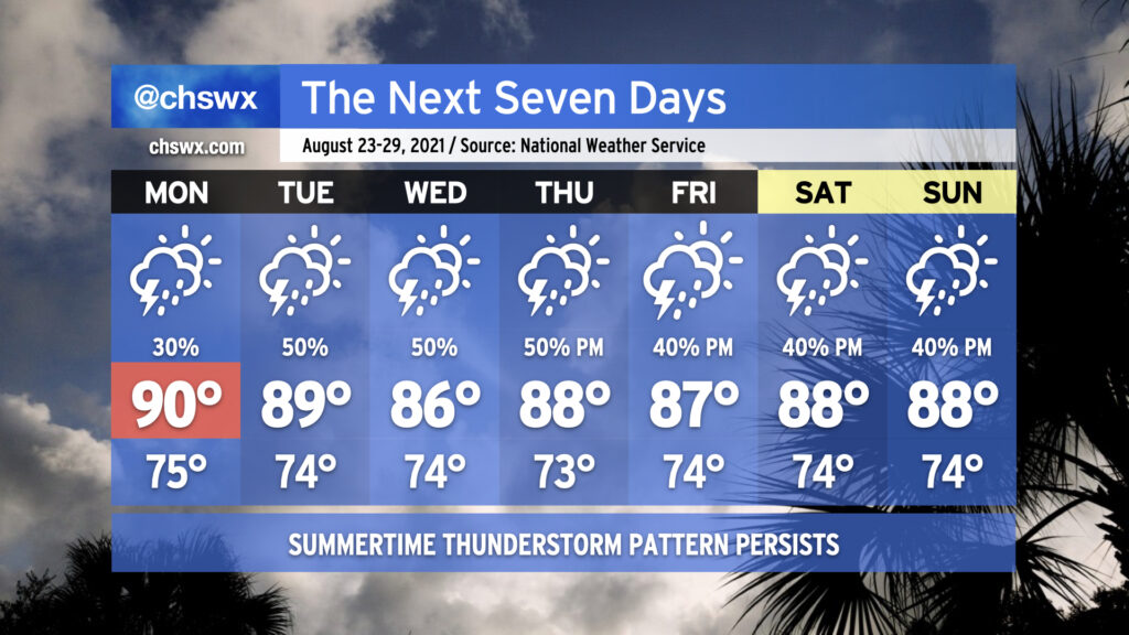
We’ll remain in a somewhat unsettled regime of afternoon showers and thunderstorms each day this week as tropical moisture continues to hang tough in the Lowcountry. Temperatures will generally top out in the upper 80s to around 90° each day. Mix in the humidity and it’ll feel closer to 100°. Not everyone will see rain every day, nor will it rain all the time, but you’ll want to keep a close eye on the weather if you have outdoor plans this week.
Taking a look at the numbers, it’s been a very, very soggy August. 10.83″ of rain at the airport — including August 15’s 4.08″ deluge — is good for fourth wettest to date (as of August 21). Only 1940, 1969, and 1974 have seen wetter starts to the month. We’re a few well-placed downpours away from making a decent run at August 1940’s monthly record of 17.24″ with ten days to go (including whatever falls between the trace of rain at 5PM through the end of the day).
If there’s one bit of good news, though, it’s that the tropics are largely quiet. Henri made landfall in New England earlier today, and with that, there are no named storms in the Atlantic basin. NHC is keeping an eye on an area of disturbed weather near the Cabo Verde Islands, but as of this writing only gives this disturbance a 10% chance of development over the next five days. Otherwise, a round of Saharan dust is going to help keep things at bay a little bit for at least the next few days — suffice to say, we will take whatever break we can get from the tropics in late August. The climatological peak of the season arrives September 10.
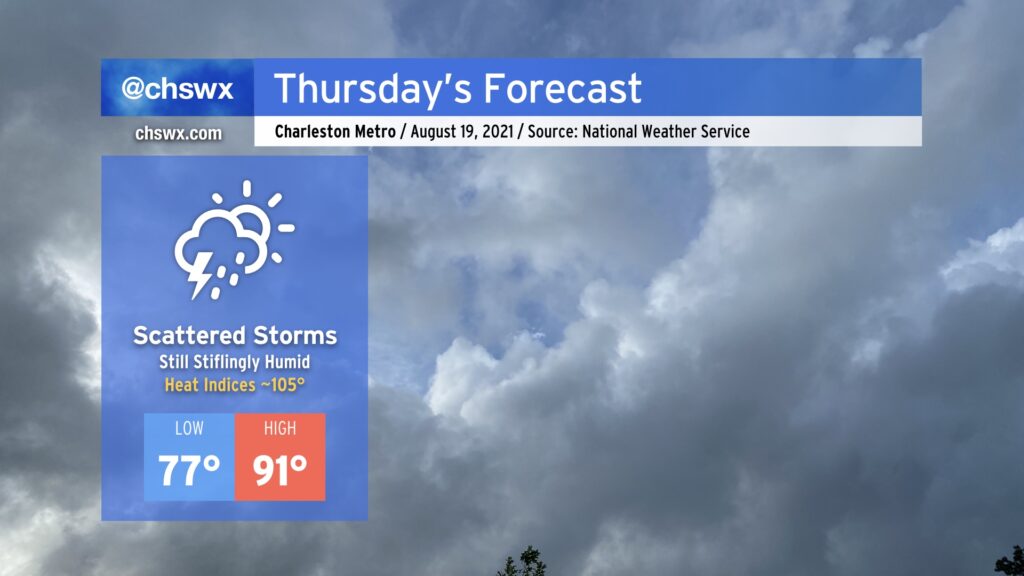
Fred may be long-gone, but its tropical moisture continues to linger across the Lowcountry for another day, making for another round of stifling heat for Thursday. Temperatures will head into the low 90s; combine this with heinous dewpoints in the upper 70s, and that will yield heat indices around 105°. This is getting to the point where heat stroke becomes a real possibility, so be sure to take plenty of breaks in the shade and get plenty of hydration if you must be outside in the heat of the day.
Some will see relief through showers and thunderstorms. In fact, there is a small chance of storms once again in the morning if the High-Resolution Rapid Refresh model has anything to say about it, so we’ll want to watch that trend. Otherwise, we should see another round of scattered afternoon thunderstorms as the heating of the day kicks in and the seabreeze makes its trek. Once again, storm motions won’t be terribly fast, and with precipitable water values at or over 2”, flooding certainly cannot be ruled out in spots.
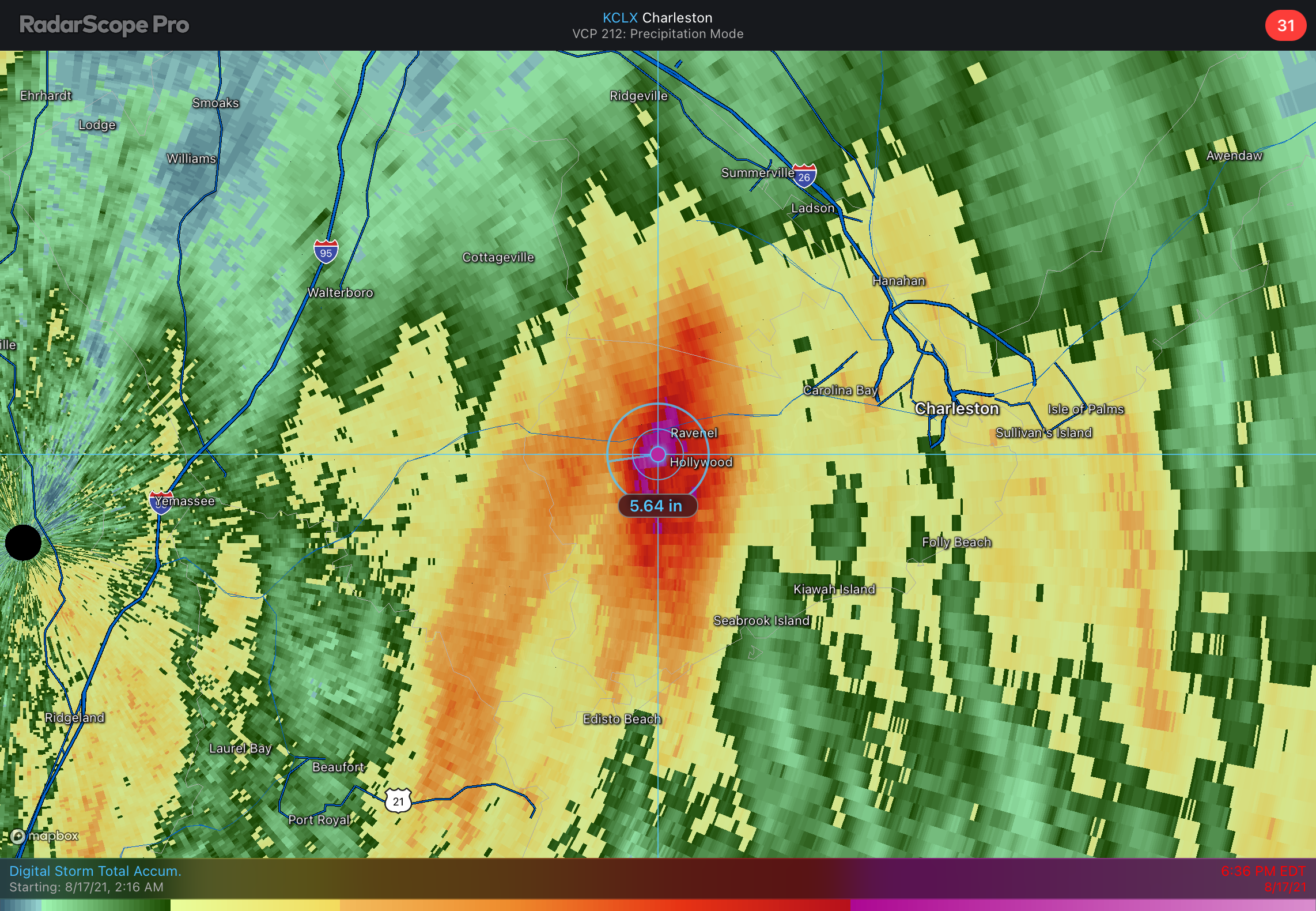
Fred continues to move northward across the western Carolinas this evening, bringing quite a ruckus including significant flash flooding in the NC mountains and several tornadoes. For our part of the Lowcountry, heavy rain has been the story. Heavy rainfall closed roads this morning in parts of downtown Charleston, while a stationary downpour within a rain band produced a radar-estimated 5-5.5” of rain across Ravenel and Hollywood.
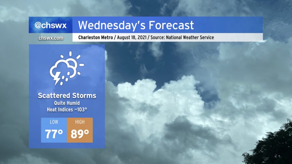
As we get into Wednesday, Fred’s remnants will become long-gone, but its legacy of deep tropical moisture will remain. An airmass characterized by surface dewpoints in the upper 70s will linger, keeping things rather humid across the region. Heat indices look to top out in the low 100s despite the fact we may not even crack 90° tomorrow.
We may start the day with heavy downpours near the coast. High-resolution models have had a pretty consistent signal that lingering banding features from departing Fred may help kick off a few showers and thunderstorms during the morning hours, which might have impacts on the commute. Afterward, high pressure aloft will increasingly reassert itself, which indicates generally scattered showers and thunderstorms developing on the seabreeze in the afternoon. Storm motions will be slow and largely driven by the inland progression of the seabreeze, so pockets of very heavy rain cannot be discounted. Otherwise, though, there will indeed be a mix of sun and clouds, so it won’t be total gloom like we’ve seen the past day or two.
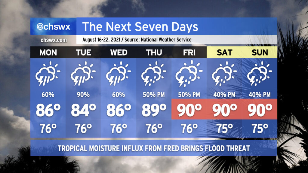
Our soggy summer rolls on with the return of widespread showers and thunderstorms for the first part of the week, particularly as Tropical Storm Fred makes landfall along the Florida Gulf Coast sometime tomorrow and moves northward through western GA into TN. While we won’t see direct impacts from Fred, we are certainly going to be within a plume of deep tropical moisture for the next several days, and this will lead to heavy downpours as a result. Models certainly suggest Tuesday as the wettest day as Fred lumbers up the AL/GA line. A few more inches of rain will certainly be possible, especially in isolated spots where the heaviest downpours occur. We’ll need to keep a close eye out for flooding issues, especially if heavy rain occurs near high tide downtown. The rainfall will keep temperatures in the mid-80s through Wednesday.
As we get into Thursday, Fred’s remnants will be out of the way and we look to begin to return to a somewhat more normal afternoon thunderstorm pattern heading into the weekend. Temperatures will respond by heading back to around 90° each afternoon before thunderstorms fire up.
We in #chswx continue to track two tropical systems in the Atlantic basin, Fred and Grace. Fred has opened up into a tropical wave for the time being, and is thus not currently a tropical cyclone, but is expected to reorganize into one and approach the Florida Panhandle as a tropical storm. Grace, meanwhile, is bringing very heavy rain to the Lesser Antilles this evening as it generally follows in Fred’s footsteps. The good news is that there are no immediate tropical threats for the Lowcountry and the rest of the Carolinas.
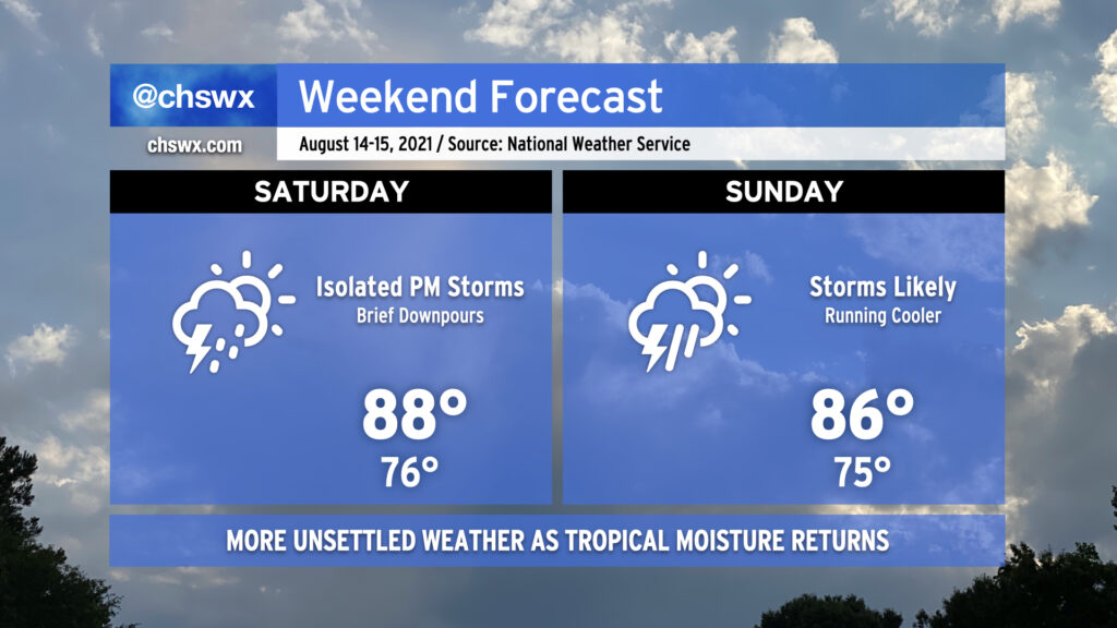
Pro tip: Mow the lawn Saturday morning, because we could start to see some showers and storms enter the picture in the afternoon as high pressure begins to weaken across the area. It’ll still be warm, but temperatures will be limited to the upper 80s by more pervasive cloud cover.
Why mow Saturday? Because Sunday is going to be a lot tougher to get that mowing in, and it doesn’t get better getting into next week. Showers and thunderstorms look to become a little more widespread Sunday, with on-and-off storms possible for a good bit of the day. As usual in summer, it won’t rain all the time, but when it does, a brief downpour or two could drop a decent amount of rain.
As we get into next week, a continued feed of tropical moisture and a stalled front will interact will keep scattered to widespread showers and thunderstorms in the forecast, particularly in the afternoons.
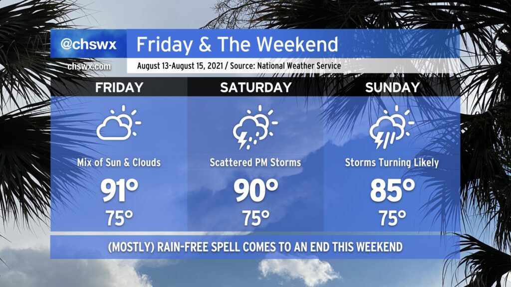
Friday gives us one more day of warm and mostly rain-free weather before the pattern turns back toward being more unsettled. Like today and the past few days, expect highs to top out a little over 90° in the afternoon, with heat indices in the low 100s. As always, a stray shower or thunderstorm can never be ruled out because, well, summer.
Our quieter weather pattern begins to shift back toward a more unsettled setup as the weekend wears on. Expect scattered thunderstorm coverage on Saturday, with highs topping out around 90° outside of those storms.
A front will sag southward into the area as we get into Sunday, stalling out over the Carolinas as Fred — forecast as a tropical storm — approaches the Florida panhandle (based on the current NHC forecast). The influx of tropical moisture with the nearby frontal boundary could spell some heavy rainfall at times across the area starting Sunday and into early next week. Stay tuned to forecast updates as the rain threat evolves.
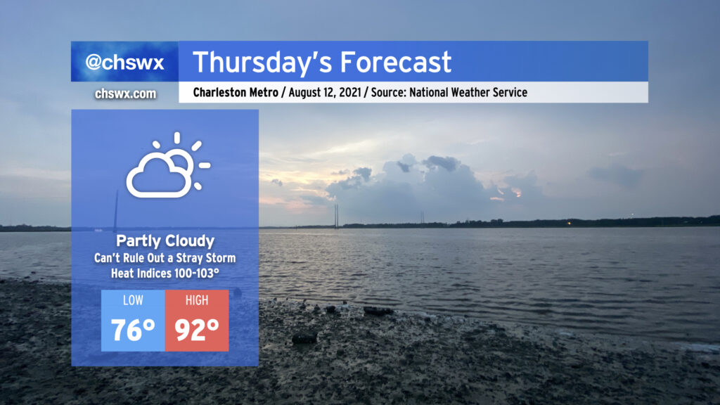
Thursday looks to be much the same as the previous few days: Temperatures in the low 90s, heat indices in the low 100s, and mostly rain-free conditions (with the disclaimer that a stray storm can never be ruled out this time of year — ask Goose Creek and Summerville all about that today). High pressure continues its firm grip on our weather both at the surface and aloft, and this looks to continue for a few more days before a front and enhanced tropical moisture moving into the area ahead of Tropical Storm Fred begin to increase rain chances to start next week.